
36 hours & 2 broken bones on Cairn Toul - Braeriach Traverse
Route: Cairn Toul - Braeriach traverse
Munros: Braeriach, Cairn Toul, Sgòr an Lochain Uaine, The Devil's Point
Date walked: 26/02/2015
Time taken: 36 hours
Distance: 41km
Ascent: 2000m
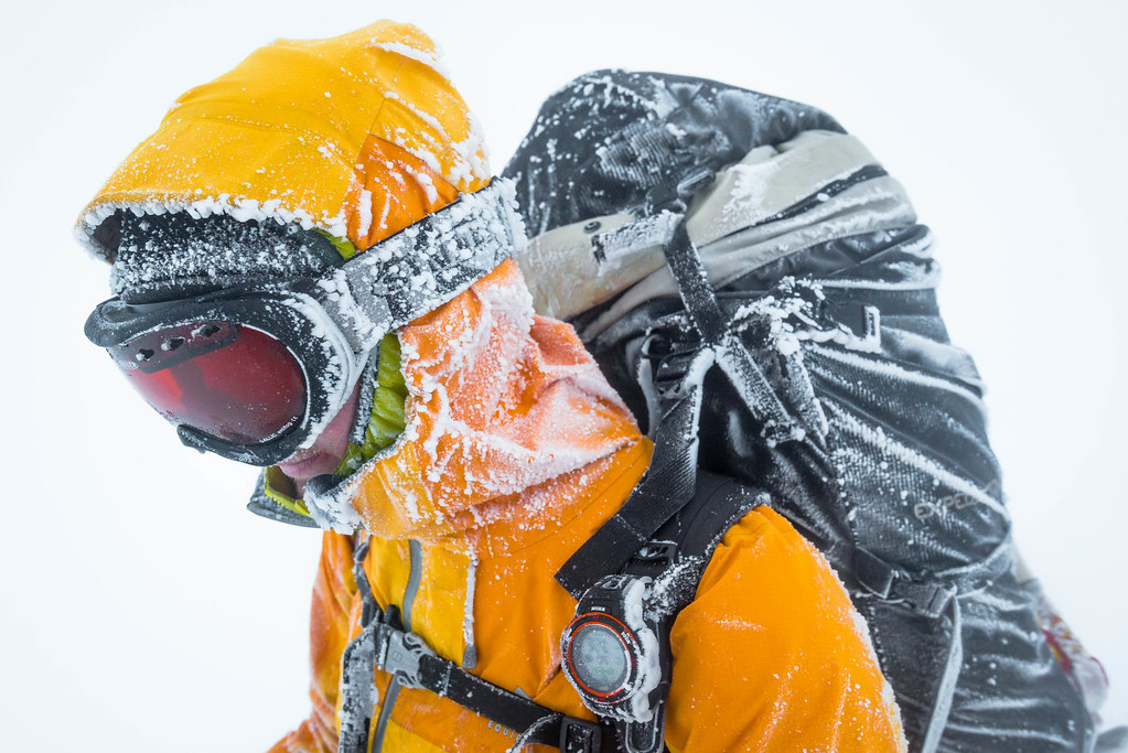 Rim on Braeriach by AlexFrood, on Flickr
Most of my reports begin with “I woke up in my van” but not this report. This time when my alarm went off on a Friday morning I was in my own bed in the north east of England. (I do in fact have a place to stay which isn’t my van, but not everyone believes this.)
This alarm was set for 5am as that was when my good friend Keiran was turning up in his van outside of my flat as I was the one driving today. I’m sure my neighbour was pleased with the sounds of doors closing and diesel engines idling at 5am. After a few minutes of moving our kit/storage crates into my van we were ready for the 7 hour drive to Aviemore. Well ready apart from the frozen windscreen. As we waited for the ice to melt I set the GPS and put on a new playlist I found on Spotify™ called “ Drive through the Mountains”. (Check it out, really chilled music and great when snow covered Scottish mountains are going past the windows.)

When it was time to go, we set off north. The drive was easy going and we watched the sun rise as we passed over the A66. The drive was filled with talk of adventures past and future with my long term friend and colleague Kieran, as well as us checking the SAIS and MWIS forecasts for weather reports.
The final plans were set. We planned a Friday to Sunday exped in the hills with a night in a bothy and snowholing, planned on taking in the summits of The Devil's Point, Cairn Toul, Sgor an Lochain Uaine and Braeriach via Lairig Ghru. The weather was going to be ok with whiteout midday Saturday and high winds on Sunday.
Little did we know what was in store for us. Longer days and shorter time frames, sore feet and broken bones.

We made it to Aviemore where we stocked up on food and fire wood for the bothy night. From there I drove us to the Whitewells car park where we planned to start the walk. We packed the exped rucksacks and filled them with all the normal winter hill kit plus sleeping kit, firelogs and food for three days. Putting the packs on our back, we found they were a pretty decent weight, but we didn’t really mind as they would be getting lighter when we left the bothy the next day. After all it was only a “short” afternoon walk up the Lairig Ghru to the Corrour bothy. Fair to say I had studied the map for the mountainous parts of the trip but I hadn’t really looked at the Lairig Ghru on the map, nor had I been there before, so I didn’t know it was a 17km walk over the 800m+ pass to get to the bothy.
We set of about 3pm in the late afternoon sun and with blue skies, after I had been up since 5am and driven for 7 hours, but we made a quick 5-6km pace eager to get into the hills and make the most of the light which was left. After the tracks turned to a more rocky path my friend switched from his approach shoes to his winter boots, which are plastics, warm but not great for walking on the flat, more on that later. I just wore my trusty Nepals the whole time.
We carried on at our fast pace for some time, only really slowing when we started to reach the higher parts of the Lairig Ghru and the snow appeared underfoot. After a wee break here the first little problem of the trip came up when the zip slider of my mate’s waterproof snapped, making it really hard to zip the jacket up; not good when you’re in the winter hills and with snow and wind predicted. Also not good when it’s even harder to grip what’s left of the zips metal when you’re wearing big frozen gloves as well. Although this was my mate’s jacket , in time it would become my problem as well.
We lost the last of the light about a km before the top of the pass but had a nice view looking back down the Lairig Ghru where the steep craggy sides where framing the lights of Aviemore below.

After reaching the high point of the Lairig Ghru in darkness we made a small error where we followed a spur for a few hundred meters. After realising this we back tracked a little bit and descended to the Pool of Dee.
The Pools of Dee was a strange sight to see in the darkness. The whole area was covered in deep Consolidated snow with large holes which dropped away like large sink holes into dark waters which were the larger of the pools.

At this point we remembered the signs we had seen hours ago about a bridge being washed away. We didn’t really know which bridge it was, so we played it safe and guessed it could be the one next to the Corrour bothy. I made up my mind: we would try and stay on the path on the east side of the river but cross it before it became too big so we were on the west and bothy side in case it was the bothy bridge what was down.
We followed the river’s edge as the path had disappeared on the east side for a few more km before deciding to cross when it started to flatten out at the top of Glen Dee. At this level the nice strong snow bridges we had been over had disappeared, so we looked for the shallows to try and cross. We found an area and crossed quickly, then found we had crossed onto an island, so we then scouted along the shores of our little island to find another crossing to finally find the west side of Glen Dee. It didn’t take long to find a spot and get across, both of us still with dry boots. We felt like it was time for a short break as we had been going non-stop for a few hours by now, we turned off our head torches and sat in darkness, slowly as our eyes adjusted to the lack of light the large dark hulks of Ben Meacdui, Braeriach and Cairn Toul started to outline themselves against the black but starry sky. Sitting there in the inky black of the night it made me feel very small to be surrounded by three of the largest ageing giants in the UK.
It was time to move again and for me to snap out of my little fantasy of darkness and giants. We carried on the slog through snow-covered heather on the southerly heading to find the Corrour bothy which seem like it went on for ever. After another hour or so moving we came cross an old frozen foot print, then another and other in the snow, a good sign we were getting close to the bothy. Then out of the darkness a stone building appeared. We had made it, finally, made it.
It was time to get the fire going, and our damn packs off. Opening the door we were greeted by a quiet and cold bothy. I did think there would be others and understood the Corrour is normally a busy bothy, but not tonight.

After the packs and boots were off, the fire was goal number one. Not because we were cold or really needed one, It is just that fires are nice. We removed all firelogs of which we had two each in our bags. Taking them out, we realised how heavy these logs really are each. Turns out firelogs are really hard to light on their own. I’ve used them before in bothy but only when there has already been a fire going. Not even using a jet boil to light them worked. After 20 minutes of trying to use a jetboil and firelighters only a small parts of the firelogs had blackened and that was about it. We gave up and put a candle in the fire place and thought that will do it a fire as least.
I was pretty tired by this point, having driven 300 miles and walked 17km over a pass with a exped rucksack, I felt like I should be. I really couldn’t be bothered with cooking food and just wanted to sleep, but I knew better. Working as a guide I’ve seen far too many people not eat after a hill day and then be drained when they wake up. I see it all the time when I’m taking people up Scafell Pike on a 3 peaks at 3am and they hadn’t eaten after the Ben and just slept in the minibus. I guess the more I eat anyway, the less I have to carry tomorrow; a day with more ascents and height gain.

It was finally time for bed, I pulled out a borrowed sleeping bag. My normal winter bag was off being repaired, as the zip slider had broken as well, another ME product with a broken zip.
Well, Id say it was time for bed but I still needed to cook, which I decided would be done from inside my sleeping bag. I did manage to cook and eat whilst not falling asleep in the process but I did set a countdown alarm on my watch just in case.

We awoke to a crisp but sunny day deep in the Cairngorms. I stepped outside for the first time and saw the impressive black crag clad sides of Devil’s Point behind the bothy. Once breakfast was made, the now a wee bit lighter packs where packed and on our back and it was time to go. We headed into Coire Odhar, quickly making up the first part of the hill and seeing the back of the coire heavy laden with snow we decided not to go for the normal Bealach route and just headed straight south up the side of Devil’s Point. We started to crampons up as the snow was bullet hard which started to ring alarm bells for the snowholing plan. It wasn’t long before we we were on the final ascent to the summit. We dropped the bags and set a bearing between the summit and bag in case the clag came out which was unlikely with the blue skies. We soon started to miss the weight and comforting hug of the rucksacks as our backs started to get a bit cold.

We soon stood on the summit of Devil’s Point, the first summit of the day with some cracking views of the Cairngorms unfolded in front of us, with its meandering rivers and other mountains. This view also gave us a scale for how far we had come the night before.

Next up was the summit of Stob Coire an t-Saighdeir on the way up to the munro of Cairn Toul. The weather was still fine where we were but we could see the summit of braeriach was starting to be covered in clag. The walk wasn’t hard just a bit of a slog following the snow. The top of the ridge was stripped of snow but the rocks made it slower going, so sticking to the snow was the faster option. We soon made the top and carried on to Cairn Toul.
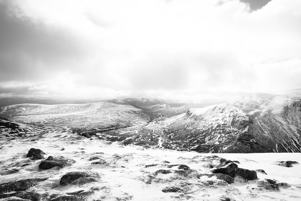 Glen Dee from the Summit of The Devils Point by AlexFrood, on Flickr
The walk up to Cairn Toul was short but a bit slower and there was only ice and rocks to walk on which took much longer to do, but it wasn’t too long before we were hiding behind the summit cairn from the now picking up wind. So that was munro number two for the day. Next was the short walk down and up again to munro number three, Sgor an Lochain Uaine or The Angels peak.

This is where a simple down and up again went wrong. Not long after leaving the summit of Cairn Toul, my friend slipped and landed thumb first. The thumb on contact with rock made some odd noises and moved in ways thumbs are not meant to do. Kieran said it was broken, however, this wouldn’t be confirmed for a few days until he got it X-rayed. We could tell it was bad, as Kieran struggle to take off his outer glove, then put it back on again. He didn’t bother taking the inner glove off until he got off the hill and in the van, this wouldn’t be for another 12 hours but from the look on his face when trying to use it was probably the better idea. This is when Kieran’s broken jacket zip slider from the day before now became my problem as he couldn’t do it with one hand.

We carried on to the next summit, (not that we had a choice in that matter). Once we made the summit of Sgor an Lochain Uaine it was finally time for lunch. Well, Ii say finally, it was the first time I’d looked at my watch and I saw it was 3pm. After my classic hill lunch of pork pies it was time to move again before we got cold. Here is where we found the next set of problems with Kieran’s hand, he couldn’t get rucksack straps or clips sorted on his own so that was something else he needed help with for the rest of the day and quickly approaching night.

The was only one final ascent to go up to the Carn Na Criche area before the flatish walk over to Braeriach.

The bullet hard snow, broken thumb and forecast 70mph+ winds for Sunday made a changes in the plan. We decided to skip the snow hole and do day 3 walking today, finally heading out via Gleann Eanaich. That meant we were now doing Braeriach today.


We reached the Braeriach plateau via Carn Na Criche, and we were now in the clag. The wind had picked up, the snow was being blown and the rime was starting to form on us. The day was fading into the night and this was how the next few hours would be spent.

The plan was to do some nav legs between the spot heights marked with cairns up on the plateau and then a bearing east to the summit of Braeriach.


My walking on a bearing for a distance went fine, which was one of the main areas I was looking at practicing nav wise for my WML assessment, but I made a silly nav error when I got on to the plateau and sort of put myself at the wrong cairn about 200 meters from the one I was at. I would have seen my error if I was using a 1:25k map at both are on there, the 1:50k map only had one on it. Oh well, my error was fixed and we were on the final leg to the summit of Braeriach.

It was time to walk into the growing darkness, clag and snow for the final ascent of the day on the final mountain of the trip. I set a bearing and aimed way off to the north of the summit as I didn’t want to be anywhere near the cliff edges in the clag and darkness. The bearing was set and walked, we soon did the final 80 meters of ascent to the summit area.

We set another bearing to follow the edge and follow a hand rail to the summit cairns. It wasn’t long before we came across the cairn, got the summit selfies I always take, and it was time to back track to a spot height on the west of the plateau.

But the time we finished this bearing to the spot height at the west of the plateau the light of the day had finally died, the head torches were out and the rime was building thickly on our kit. By the time we got there I think it was a about 6:30pm and we still had a long way to go. The plan was to follow a north west spur down into the Gleann Eanaich. This turned out to be pretty easy nav wise as it was pretty broad and had no steep crags to worry about but was a slog, dropping 700 meters in height.

Time went on and on and slowly it started to flatten out into the glen floor. This is where we started to realise how much snow had fallen over the last 12+ hours. Gone were the old snow patches and mountain flora, they were replaced with fresh snow. Being in the bottom of the glen it’s nice to be out of the wind which were still blowing high above our heads. The fresh snow lay upon the carpet of heather of the glen floor. It was fun walking in the heather leaving dark trails of snow-less heather were our movement knocked the snow from them. You could also see the dark snow-less heather tracks of the deer and mountain hares which had been moving though the area.

After what seemed like an endless time of walking in the heather we finally came upon the landrover track in the glen. All that was left to do was to hop over the water filled ditch at the side and we were on the track, the lovely flat, easy walking track. As I made my way over the ditch I slipped putting a crampon spike into my left knee, well done you idiot! Lucky for me there was no major hole in my waterproofs or me!

After both making it onto the track we de-cramponed and were ready for the remaining 8km walk out back to the van. I once again helped Kieran with his zips and rucksack clips because of his broken thumb, by this point it had been broken for a good 10 hours, but I did tell him he only needed one hand to pee…
We set off on the final part of the trip. The march out of Gleann eanaich.

I didn’t envy Kieran walking out 8km on the flat in B3 plastic boots. This was obvious by the more and more frequent stops for Kieran to rest his feet By this time I had to pick his rucksack up whilst he would try to stand up again after each sit down stop.
The hours drew on and the km slow dropped away. The heather was gradually replaced with more and more trees until we were fully in the forest. As we had a stop next to the sign pointing out the turn off for the Lairig Ghru: were we were less than 36 hours before. That meant we were less than 1km from my van, less than 1km from salvation from the pain in our feet and the weight on our backs.
It was one final push to the van and 15 minutes later, there it was, my proud yellow winter home was sitting where I left it. That’s good! It was now covered in the snow. Now then, which pocket did I put the keys in… .
I hope you have enjoyed the report.
One final note: I am a good friend and offered to drive Kieran to Fort William A&E (nearest I could think of) as soon as we got to the van to get his thumb examined. He declined. When we were in the van and parked up for the night I helped Kieran out of his jacket and he slowly took off his inner glove. His thumb was an interesting size and shades of dark and light purple mixed with green from the top of his thumb to the bottom of it near the wrist. It was later confirmed to be broken in two places.
Click to mark this as a great report. Register or Login free to be able to rate and comment on reports (as well as access 1:25000 mapping).
Comments: 18
A winters day on Ben Vane.
Munros: Ben VaneDate walked: 15/02/2015
Comments: 1
Views: 4706
White out on Carn na Caim & A'Bhuidheanach Bheag
Munros: A' Bhuidheanach Bheag, Càrn na CaimDate walked: 11/02/2015
Comments: 5
Views: 4300
A night on A’Mharconaich
Munros: A' MharconaichDate walked: 09/02/2015
Comments: 2
Views: 3401
Late afternoon sun on Geal-charn
Munros: Geal-chàrn (Drumochter)Date walked: 05/02/2015
Views: 2413
Hard snow and new friends on An Caisteal & Beinn a’Chroin
Munros: An Caisteal, Beinn a' ChròinDate walked: 01/02/2015
Comments: 6
Views: 7072
Alpine Forests and Beinn a’Chleibh
Date walked: 31/01/2015
Comments: 3
Views: 4098
Blue sky's on Beinn Dorain & Beinn an Dothaidh
Munros: Beinn an Dòthaidh, Beinn DòrainDate walked: 21/01/2015
Comments: 3
Views: 5809
Comets & shooting stars over Ben Challum
Munros: Ben ChallumDate walked: 18/01/2015
Comments: 13
Views: 11625
Sunset over Ptarmigan ridge on Ben Lomond
Munros: Ben LomondDate walked: 18/01/2015
Comments: 8
Views: 24161
-
AlexFrood
- Occupation: Rock Climbing instructor
- Activity: Stravaiging
- Pub: SouthField
- Mountain: Clisham
- Place: Aviemore
- Gear: Rab Latok Waterproof
- Member: Chairman of Teesside Uni Rock Climbing Club
- Camera: LUMIX GH3
- Munros: 69
- Corbetts: 3
- Wainwrights: 24
- Hewitts: 29
- Filter reports
- Trips: 13
- Distance: 57 km
- Ascent: 2000m
- Munros: 24
- Trips: 2
- Distance: 27 km
- Ascent: 1760m
- Munros: 2
- Corbetts: 1
- Trips: 3
- Distance: 169 km
- Munros: 1
- Corbetts: 1
- Joined: Mar 30, 2013
- Last visited: Jun 07, 2021
- Total posts: 37 | Search posts