
Ben More via NE Ridge (Cattle-free)
Route: Ben More and Stob Binnein
Munros: Ben More
Date walked: 25/08/2017
Distance: 12km
I wanted to do Ben More with my two Beagles and was concerned about running into cattle if we followed the standard route up from Ben More farm. Someone in the forum suggested trying an alternate route up via the NE ridge, and I'm happy to report this was not only cattle-free, but also I suspect much less of a head-down slog than the standard route. Here's a rough guide for anyone wishing to try this alternate route.
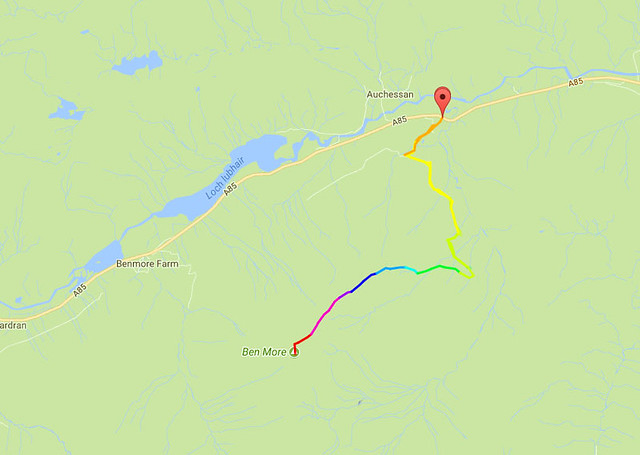 BenMoreRoute by Paul Roberts, on Flickr
1) Park in the small lay-by on the A85 at 56.415110, -4.506000 (satnav / Google Maps coords). Head straight up the bank at the back of the lay-by to a wire fence. The fence is low but if you've got dogs take care to lift them over it rather than letting them jump it, then get over it yourself. If It's a warm day be sure to rip you trouser leg on a bit of stray barbed wire as you do so; this really helps with ventilation later in the walk.
2) To your right you'll see a small fenced building. Head over to this and follow the fence until you reach a gate by a forestry road. Go through this first gate, then up through the next gate immediately on your left. Just follow the road uphill now. Early on there's a T-junction of sorts; go left to keep heading up.
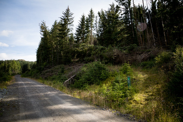
3) The guide I originally found for this route told me to turn right into the trees by a little cairn after about a mile or so. I really hate it when key nav points depend on the activities of Rodney The Random Cairn-Maker. More often than not the cairn is either long gone, or is surrounded by a multitude of bogus cairns, some of them built to celebrate a particularly satisfying dump, others made for no good reason at all. In this case the cairn was missing, but in its place was a much more trustworthy green "Open hill access" marker post. Here's a shot of the turning point, and I'd say it's more like 2km up from the gate:
 5D4_5171 by Paul Roberts, on Flickr
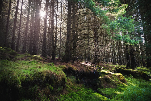
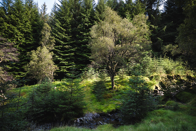
3) Follow the trail up through the trees. It's much easier on the eye than the forestry road and appears to be quite well maintained (fallen trees recently cut to keep the path open):
 5D4_5176 by Paul Roberts, on Flickr
 Forest Section Below Ben More [5D4_5191] by Paul Roberts, on Flickr
 5D4_5195 by Paul Roberts, on Flickr
You'll cross a stream after a little bit; nice fresh drinking water for the dogs.
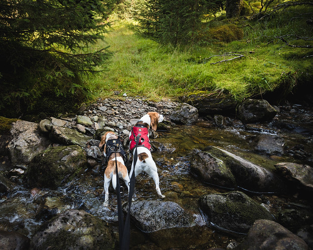 5D4_5206 by Paul Roberts, on Flickr
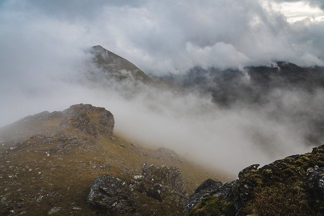
4) Eventually you come to another "Open hill access" sign that marks the end of the forest trail, and the start of the obligatory bogfest. Head uphill a short way until you can see the lie of the land.
 5D4_5221 by Paul Roberts, on Flickr
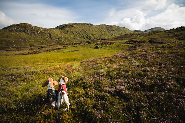
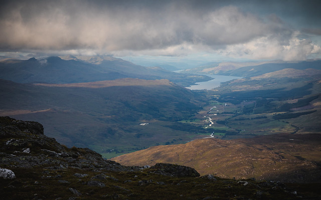
Up ahead is a fairly recent deer fence with a stile. Head to the deer fence but don't go over the stile, just follow the fence to the right and uphill for a while as you head in the general direction of Ben More's NE ridge. Eventually the fence turns off leaving you clear to head up to the ridge across yet more boggy, energy-sapping field, crossing a burn or two on the way. Once you get onto the ridge the hard slog is done; a reasonably clear path takes you all the way up to the summit of Ben More. It's still boggy and slippy in places, but not nearly as bad as that blasted field, and all the while you're gaining height and better views.
 5D4_5226 by Paul Roberts, on Flickr
 5D4_5232 by Paul Roberts, on Flickr
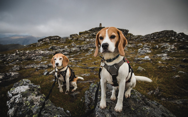
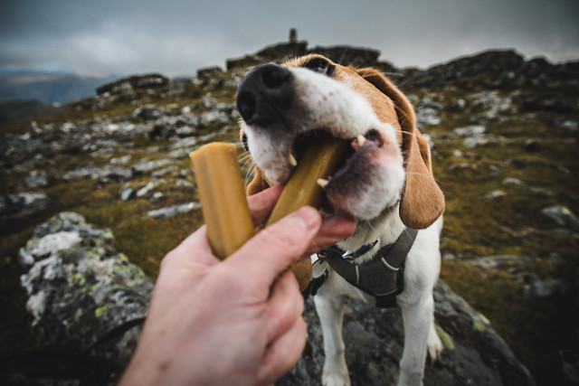
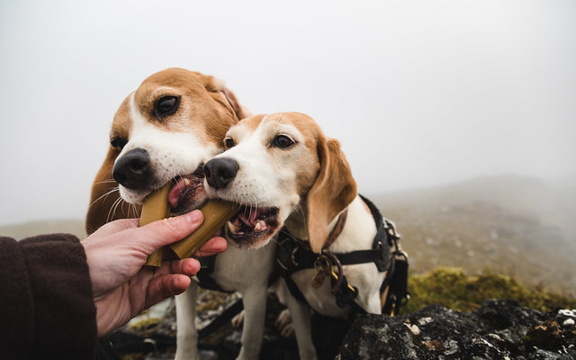
As you can see the weather was great on the way up and the top was clear of cloud as we reached the very grand looking cairn. Rather than continuing on to Stob Binnein my plan was just to get some photos of it from Ben More in golden pre-sunset light. There didn't seem to be any need to hurry on that account, so I swapped my sweaty top for a dry thermal, took a good swig from my water bottle and served up a couple of mini-jumbones to my furry companions.
 5D4_5241 by Paul Roberts, on Flickr
 5D4_5243 by Paul Roberts, on Flickr
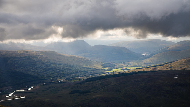
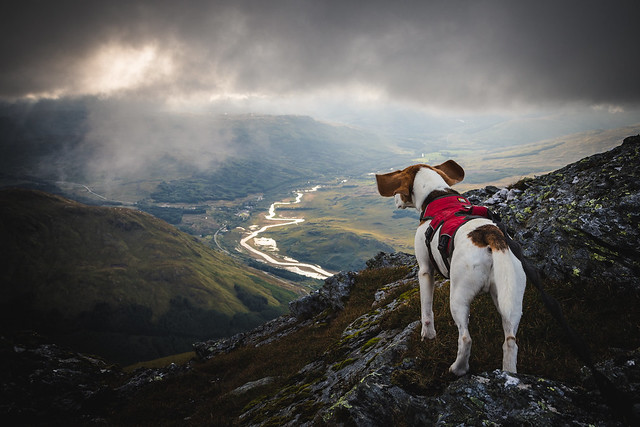
If you believe the Pedigree TV advert, Jumbones - even the little ones - are supposed to go om n' nom 'n' nom for ages. My Beagles had them finished in only 35 secs, but even this was long enough for the clouds to sweep in. We hung around at the summit for about an hour; I grabbed a few shots whenever conditions cleared slightly and the pups munched through two more mini-jumbones and a big pair of cow ears (no longer attached to the original bovine owner) but the cloud never cleared enough to give me the kind of views Ben More has to offer.
 5D4_5248 by Paul Roberts, on Flickr
 5D4_5256 by Paul Roberts, on Flickr
 5D4_5285 by Paul Roberts, on Flickr
 5D4_5290 by Paul Roberts, on Flickr
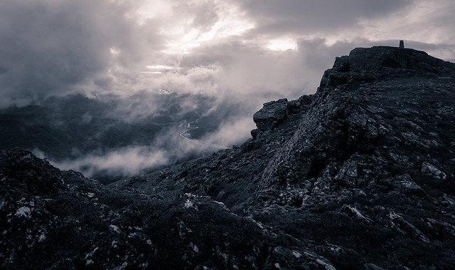 Ben More Trig Pano [5D4_5306] by Paul Roberts, on Flickr
Just before sunset I called time on our little adventure and we set off back down. I didn't need the head torch until we were off the ridge and slogging our way back through the bogfest. It seemed to take an age to get through that, but once we got back to the forest trail it was very easy going.
So to sum up this approach appears genuinely cattle-free (though you will encounter sheep and the odd deer, so keep dogs on lead throughout) and trades a bit of extra distance for what is probably a much less aggressive ascent than the default route.
BenMoreRoute by Paul Roberts, on Flickr1) Park in the small lay-by on the A85 at 56.415110, -4.506000 (satnav / Google Maps coords). Head straight up the bank at the back of the lay-by to a wire fence. The fence is low but if you've got dogs take care to lift them over it rather than letting them jump it, then get over it yourself. If It's a warm day be sure to rip you trouser leg on a bit of stray barbed wire as you do so; this really helps with ventilation later in the walk.
2) To your right you'll see a small fenced building. Head over to this and follow the fence until you reach a gate by a forestry road. Go through this first gate, then up through the next gate immediately on your left. Just follow the road uphill now. Early on there's a T-junction of sorts; go left to keep heading up.
3) The guide I originally found for this route told me to turn right into the trees by a little cairn after about a mile or so. I really hate it when key nav points depend on the activities of Rodney The Random Cairn-Maker. More often than not the cairn is either long gone, or is surrounded by a multitude of bogus cairns, some of them built to celebrate a particularly satisfying dump, others made for no good reason at all. In this case the cairn was missing, but in its place was a much more trustworthy green "Open hill access" marker post. Here's a shot of the turning point, and I'd say it's more like 2km up from the gate:
5D4_5171 by Paul Roberts, on Flickr3) Follow the trail up through the trees. It's much easier on the eye than the forestry road and appears to be quite well maintained (fallen trees recently cut to keep the path open):
5D4_5176 by Paul Roberts, on FlickrForest Section Below Ben More [5D4_5191] by Paul Roberts, on Flickr5D4_5195 by Paul Roberts, on FlickrYou'll cross a stream after a little bit; nice fresh drinking water for the dogs.
5D4_5206 by Paul Roberts, on Flickr4) Eventually you come to another "Open hill access" sign that marks the end of the forest trail, and the start of the obligatory bogfest. Head uphill a short way until you can see the lie of the land.
5D4_5221 by Paul Roberts, on FlickrUp ahead is a fairly recent deer fence with a stile. Head to the deer fence but don't go over the stile, just follow the fence to the right and uphill for a while as you head in the general direction of Ben More's NE ridge. Eventually the fence turns off leaving you clear to head up to the ridge across yet more boggy, energy-sapping field, crossing a burn or two on the way. Once you get onto the ridge the hard slog is done; a reasonably clear path takes you all the way up to the summit of Ben More. It's still boggy and slippy in places, but not nearly as bad as that blasted field, and all the while you're gaining height and better views.
5D4_5226 by Paul Roberts, on Flickr5D4_5232 by Paul Roberts, on FlickrAs you can see the weather was great on the way up and the top was clear of cloud as we reached the very grand looking cairn. Rather than continuing on to Stob Binnein my plan was just to get some photos of it from Ben More in golden pre-sunset light. There didn't seem to be any need to hurry on that account, so I swapped my sweaty top for a dry thermal, took a good swig from my water bottle and served up a couple of mini-jumbones to my furry companions.
5D4_5241 by Paul Roberts, on Flickr5D4_5243 by Paul Roberts, on FlickrIf you believe the Pedigree TV advert, Jumbones - even the little ones - are supposed to go om n' nom 'n' nom for ages. My Beagles had them finished in only 35 secs, but even this was long enough for the clouds to sweep in. We hung around at the summit for about an hour; I grabbed a few shots whenever conditions cleared slightly and the pups munched through two more mini-jumbones and a big pair of cow ears (no longer attached to the original bovine owner) but the cloud never cleared enough to give me the kind of views Ben More has to offer.
5D4_5248 by Paul Roberts, on Flickr5D4_5256 by Paul Roberts, on Flickr5D4_5285 by Paul Roberts, on Flickr5D4_5290 by Paul Roberts, on FlickrBen More Trig Pano [5D4_5306] by Paul Roberts, on FlickrJust before sunset I called time on our little adventure and we set off back down. I didn't need the head torch until we were off the ridge and slogging our way back through the bogfest. It seemed to take an age to get through that, but once we got back to the forest trail it was very easy going.
So to sum up this approach appears genuinely cattle-free (though you will encounter sheep and the odd deer, so keep dogs on lead throughout) and trades a bit of extra distance for what is probably a much less aggressive ascent than the default route.
Click to mark this as a great report. Register or Login free to be able to rate and comment on reports (as well as access 1:25000 mapping).
Comments: 3
Wild Camp on Ben Narnain
Munros: Beinn NarnainDate walked: 10/06/2015
Comments: 3
Views: 5361
1, 2
Buachaille Etive Beag(les) at sunrise
Munros: Stob Coire Raineach (Buachaille Etive Beag), Stob Dubh (Buachaille Etive Beag)Date walked: 29/05/2013
Distance: 8km
Ascent: 900m
Comments: 16
Views: 21072
The Old Man of Storr at Dawn and the Trouble with Beagles
Date walked: 24/05/2012Comments: 4
Views: 21364
Coire Lagan
Comments: 7
Views: 8553
Ben Donich in a Bothy Bag
Corbetts: Ben DonichDate walked: 16/05/2012
Comments: 6
Views: 9346
Beinn Dubh Hill Run - with our Beagles
Date walked: 12/05/2012Distance: 14km
Ascent: 850m
Comments: 7
Views: 5690
1, 2
Sunrise from the Cobbler's Central Peak
Corbetts: The CobblerDate walked: 30/04/2012
Comments: 24
Views: 21394
Narnia and back in 725 metres
Date walked: 03/02/2012Distance: 11.5km
Ascent: 725m
Comments: 8
Views: 5167
The Cobbler - Certified Beagleable
Corbetts: The CobblerDate walked: 05/11/2011
Comments: 10
Views: 7812
-
FourLeggedPal
- Location: Irvine
- Interests: Canicross - cross country running and hiking with dogs.
- Activity: Munro compleatist
- Mountain: Pap of Glencoe
- Place: Glencoe
- Member: http://www.canicross-scotland.co.uk
- Filter reports
- Trips: 1
- Distance: 12 km
- Munros: 1
- Trips: 1
- Munros: 1
- Trips: 1
- Distance: 8 km
- Ascent: 900m
- Munros: 2
- Trips: 6
- Distance: 25.5 km
- Ascent: 1575m
- Corbetts: 2
- Trips: 1
- Corbetts: 1
- Joined: Nov 06, 2011
- Last visited: Aug 01, 2018
- Total posts: 60 | Search posts