
Sky Meadows, Virginia
Date walked: 19/10/2019
Time taken: 2.5 hours
Distance: 8km
Ascent: 304m
This past June, three days after returning to the US from my most recent trip to Scotland, I loaded my car full of my worldly goods and moved from my home state of North Carolina to the northernmost county of Virginia. On the drive up, just before crossing the Blue Ridge Mountains at Ashby Gap, I drove past Sky Meadows State Park. Being a mere 30-minute drive from my new home, I decided that this place was worth investigating.
After one false start in August (still far too hot and humid), I took advantage of yesterday's beautiful autumn weather in this part of the world and completed a 5-mile loop on the park's excellent hiking trails.
Mount Bleak House, near the park office:

The very short Corporal Morgan Trail runs from the parking area, past the park office and toward the treeline, where it gives way to the dirt-and-gravel Boston Mill Road:

This easygoing trail was full of people out for the day with their kids, walking dogs, etc. But once I got onto the Gap Run Trail and started climbing up toward the Blue Ridge, the crowds gradually thinned away.
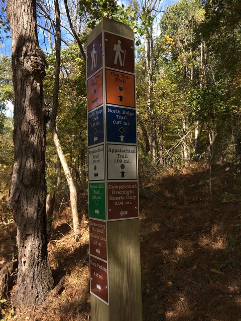
Excellent waymarking:
Conditions underfoot got a little rougher as I continued to follow the Gap Run Trail, and got rougher and steeper still when I got onto the North Ridge Trail, which was the most challenging bit of the day.
Climbing on the Gap Run Trail:

Still climbing on the North Ridge Trail:

After ascending 977 feet in 1.6 miles on the North Ridge Trail, I finally gained my ultimate goal: the famed and lauded Appalachian Trail, which runs through the western end of Sky Meadows on its 2200-mile journey from Georgia to Maine.
On the AT, looking south:

Looking north:

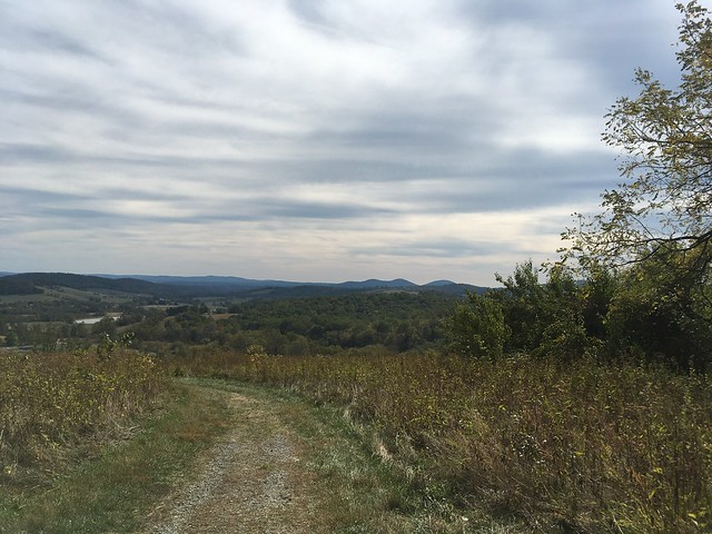
Reaching the AT also meant reaching the highest elevation of the day, and as the terrain leveled out and the trees fell away, I was treated to the finest walking and the finest views of the day.

Happy as a clam on the AT:

I walked a little less than a mile on the AT before departing it to join the Ambassador Whitehouse Trail, which began my descent back off the Blue Ridge. But not before one last panoramic view:

I eventually joined back up with the North Ridge Trail, further down the mountain from where I'd started on it.
By this time I could see where I'd parked from my vantage point on the hillside, and it was a fairly easy descent back down to Boston Mill Road and the Corporal Morgan trail to finish back where I'd started.
One of the most frequently asked questions I get when people find out I'm a walker from NC is whether I've done the Appalachian Trail. I can now say I've done 1 mile of it! And the bug has most definitely bitten me. A continuous end-to-end hike of the AT is a 6-month commitment and therefore probably beyond my scope for the foreseeable future, but tentative plans are brewing for a section-hike over my school break in March 2020, so watch this space! I'll definitely be back to Sky Meadows in any event - I'm hoping to make this at least a monthly walk, with other trails in the park worked in. It's too pretty not to go back.
Song of the day: "Big Sciota" by Jerry Douglas, Russ Barenberg, Edgar Meyer, and Sam Bush
After one false start in August (still far too hot and humid), I took advantage of yesterday's beautiful autumn weather in this part of the world and completed a 5-mile loop on the park's excellent hiking trails.
Mount Bleak House, near the park office:
The very short Corporal Morgan Trail runs from the parking area, past the park office and toward the treeline, where it gives way to the dirt-and-gravel Boston Mill Road:
This easygoing trail was full of people out for the day with their kids, walking dogs, etc. But once I got onto the Gap Run Trail and started climbing up toward the Blue Ridge, the crowds gradually thinned away.
Excellent waymarking:
Conditions underfoot got a little rougher as I continued to follow the Gap Run Trail, and got rougher and steeper still when I got onto the North Ridge Trail, which was the most challenging bit of the day.
Climbing on the Gap Run Trail:
Still climbing on the North Ridge Trail:
After ascending 977 feet in 1.6 miles on the North Ridge Trail, I finally gained my ultimate goal: the famed and lauded Appalachian Trail, which runs through the western end of Sky Meadows on its 2200-mile journey from Georgia to Maine.
On the AT, looking south:
Looking north:
Reaching the AT also meant reaching the highest elevation of the day, and as the terrain leveled out and the trees fell away, I was treated to the finest walking and the finest views of the day.
Happy as a clam on the AT:
I walked a little less than a mile on the AT before departing it to join the Ambassador Whitehouse Trail, which began my descent back off the Blue Ridge. But not before one last panoramic view:
I eventually joined back up with the North Ridge Trail, further down the mountain from where I'd started on it.
By this time I could see where I'd parked from my vantage point on the hillside, and it was a fairly easy descent back down to Boston Mill Road and the Corporal Morgan trail to finish back where I'd started.
One of the most frequently asked questions I get when people find out I'm a walker from NC is whether I've done the Appalachian Trail. I can now say I've done 1 mile of it!
Song of the day: "Big Sciota" by Jerry Douglas, Russ Barenberg, Edgar Meyer, and Sam Bush
Click to mark this as a great report. Register or Login free to be able to rate and comment on reports (as well as access 1:25000 mapping).
Comments: 1
Lessons learned on Beinn Sciathan
Sub 2000s: Beinn Sciathain (Eriskay)Date walked: 08/06/2019
Ascent: 185m
Views: 1219
Grimsay to Eriskay on the Hebridean Way
Date walked: 04/06/2019Distance: 84km
Views: 3198
The Speyside Way, northbound from Kincraig
Date walked: 19/05/2019Distance: 116km
Ascent: 1245m
Comments: 3
Views: 6416
Revisiting an old friend (The Rob Roy Way)
Date walked: 10/05/2019Distance: 127km
Ascent: 2325m
Comments: 2
Views: 6511
An attempt at Ben Lomond via public transport
Munros: Ben LomondDate walked: 08/05/2019
Ascent: 900m
Comments: 1
Views: 4980
Hadrian's Wall in 2 long days and 7 short days
Date walked: 27/04/2019Distance: 135km
Comments: 3
Views: 1775
West Highland Way in a leisurely 9 days
Date walked: 29/08/2017Distance: 154km
Ascent: 3155m
Comments: 3
Views: 4790
-
LaurenAlexandraAgain

- Location: Winchester, Virginia, USA
- Occupation: Medical professional
- Activity: Mountaineer
- Pub: The Black Bull in Leith
- Mountain: Ben Lomond
- Place: Isle of Mull
- Gear: My boots
- Ideal day out: A long walk on a good path with good beer at the end!
- Ambition: Walk Scotland end-to-end.
- Munros: 1
- Sub 2000: 3
- Islands: 22
- Long Distance routes: West Highland Way Great Glen Way Speyside Way Rob Roy Way
- Filter reports
- Trips: 7
- Distance: 470 km
- Ascent: 4959m
- Munros: 1
- Sub2000s: 1
- Trips: 1
- Distance: 154 km
- Ascent: 3155m
- Joined: Feb 13, 2019
- Last visited: Oct 15, 2022
- Total posts: 57 | Search posts
