
A hill that lives up to its name.
Route: Maoile Lunndaidh
Munros: Maoile Lunndaidh
Date walked: 26/07/2023
Time taken: 6 hours
Distance: 26km
Ascent: 772m
The meaning of the the name if this hill is , “bare hill of the wet place.” Well for me it certainly lived up to its name
Very heavy rain the previous day and through the night didn’t make this look a very good outing
By 10.30 it looked as though it might clear, so with encouragement from Ponyexpress, I decided to “go for it”
Getting to Craig I was shocked at the packed car park, but it was a Saturday. It was still raining so on with the waterproofs
But within half an hour the sun came out, so it was off with the waterproofs
When I got to the deer gate a rugged jeep type vehicle came by and stopped , the driver Jonnie, asked me where I was going , when I mentioned Maoile Lunndaidh , he asked if I on my way back I would call at the lodge, where they were staying. He said he was hoping to climb it & wanted to know what paths I found, he said there would be refreshments.
I wasn’t looking forward to the peat hags
Then I had navigation problems, with the Garmin, normally reliable, wouldn’t load the route
So then I resorted to Outdoor Active on the phone, which didn’t work too well as I hadn’t downloaded the map
Some would ask why ever wasn’t the map and compass brought out
Laziness is the simple answer and overconfidence , as visibility was very good. I was soon off course meandering through the “hags”! I did come to a burn on the side of the hill, but NOT the hill I wanted to go up
 IMG_20230709_144900_691 by Joan Howard, on Flickr
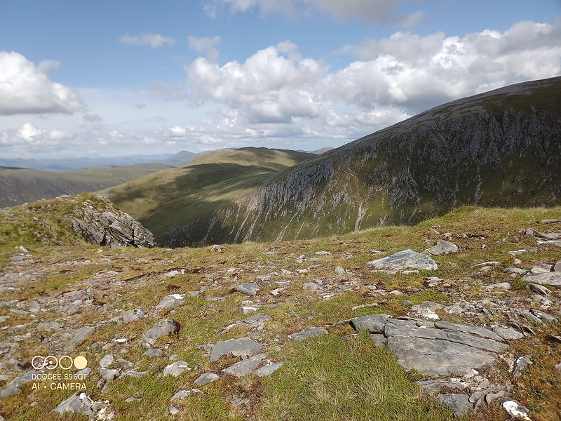
I now realised I needed to track accross the side of the mountain to make my way up to the first summit, but even more navigation errors and having come into a boulder field , I now found myself going round into the Corrie
At this point in the day I finally got the map and compass out
 IMG_20230709_161630_458 by Joan Howard, on Flickr
 IMG_20230709_161625_481 by Joan Howard, on Flickr
It was now of course fairly straightforward to the first summit.
 IMG_20230709_164120_646 by Joan Howard, on Flickr
I could see a couple ahead near the second summit , but I never got close to them, but of course a nice path to follow
 IMG_20230709_164124_307 by Joan Howard, on Flickr
 IMG_20230709_170948_355 by Joan Howard, on Flickr
I wanted to see if there was any path that I could pickup to make my way down and miss any of the peat hags
 IMG_20230709_172925_996 by Joan Howard, on Flickr
And, “yes” there is a faint path that can be picked out in the descent
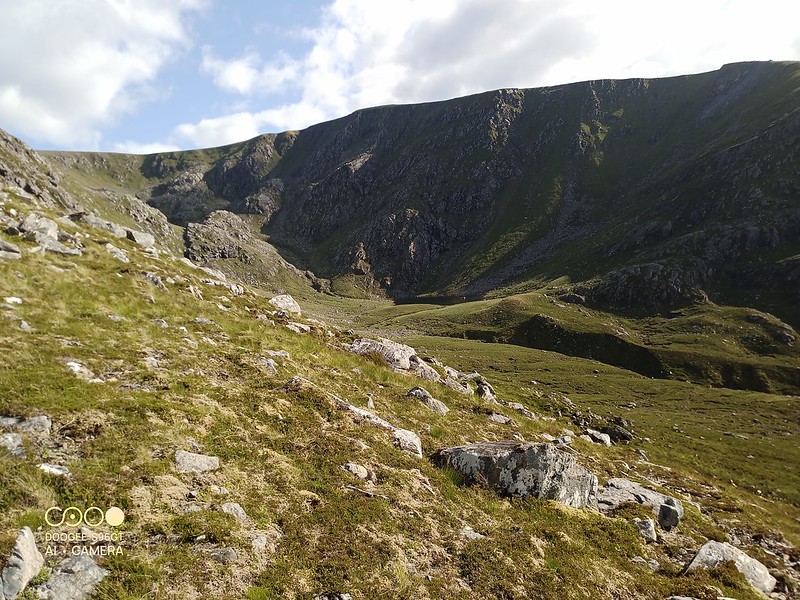
As I got lower , the sunshine broke out and there were great views into the Corrie, where I strayed earlier
 IMG_20230709_180534_624 by Joan Howard, on Flickr
I could even study where I’d managed my “escape”, before getting round to the much steeper cliffs
As I got close to the burn coming down from Creag Dhubh Mhor, I found the path fairly clearly
 IMG_20230709_181412_939 by Joan Howard, on Flickr
 IMG_20230709_181421_214 by Joan Howard, on Flickr
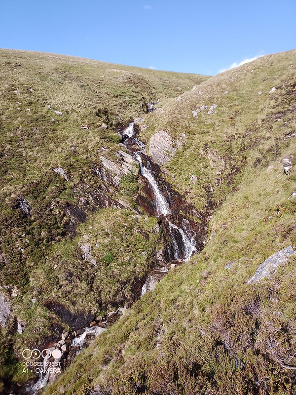
A chance to “look back” and see the amount of water flowing down the mountain
 IMG_20230709_182958_969 by Joan Howard, on Flickr
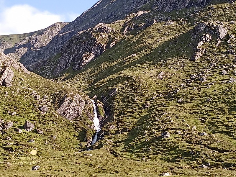
Also a good view of the mountain, looks much simpler from a distance
 IMG_20230709_182951_581 by Joan Howard, on Flickr
The ground was pretty rough, but I managed to “discern” the path, which followed the burn
 IMG_20230709_183005_301 by Joan Howard, on Flickr
As the clock was ticking , I now entered “peat hag” territory, but path eventually led to the River Meig, where I picked up a very wet land rover track, with burns to “jump”
I managed to stay reasonably dry and eventually got to Glenuaig Lodge, where Jonnie , his wife and I think her sister were enjoying the evening sunset sitting outside (no midges!) . He was as good as his word and refreshments were produced
 IMG_20230709_194740_717 by Joan Howard, on Flickr
However he saved the real “treat” as I prepared to leave, he asked if I would like to put my bike in his jeep and have a lift down the track
 IMG_20230709_194709_074 by Joan Howard, on Flickr
Click to mark this as a great report. Register or Login free to be able to rate and comment on reports (as well as access 1:25000 mapping).
Comments: 1
Stay switched on
Date walked: 21/07/2023
Distance: 23.5km
Ascent: 811m
Views: 788
Lost in the bracken
Date walked: 18/07/2023
Distance: 21.5km
Ascent: 950m
Comments: 2
Views: 413
The bothy and the bike
Date walked: 13/07/2023
Distance: 38km
Comments: 1
Views: 286
How to cross the burn in spate?
Date walked: 04/07/2023
Distance: 20.5km
Ascent: 961m
Comments: 6
Views: 977
Our final Munroes in Cairngorms
Date walked: 29/06/2023
Distance: 27km
Ascent: 1078m
Comments: 2
Views: 485
The one we missed earlier
Date walked: 26/06/2023
Distance: 32km
Ascent: 2297m
Comments: 2
Views: 393
Amazing meeting after five years
Date walked: 23/06/2023
Distance: 29km
Ascent: 1031m
Comments: 4
Views: 523
Wedding anniversary walk
Date walked: 28/01/2023Views: 351
Only one Munro with a bike ride
Date walked: 21/07/2022
Distance: 27km
Ascent: 736m
Views: 927
-
PathfinderPaul
- Location: Mold, North Wales
- Occupation: Retired Anglican vicar
- Interests: Play bridge. Allotment.
- Activity: Mountain Walker
- Mountain: An Teallach
- Place: Glen Affric
- Gear: Scarpa SL boots
- Member: North Wales Ramblers
- Ideal day out: epic ridge walk
- Walk wishlist
- Munros: 270
- Tops: 9
- Corbetts: 3
- Wainwrights: 74
- Hewitts: 123
- Islands: 15
- Filter reports
- Trips: 9
- Distance: 217.5 km
- Ascent: 7900m
- Munros: 11
- Trips: 8
- Distance: 216.45 km
- Ascent: 12345m
- Munros: 11
- Trips: 6
- Distance: 112.8 km
- Ascent: 7405m
- Munros: 7
- Trips: 3
- Distance: 39 km
- Ascent: 3547m
- Munros: 6
- Hewitts: 3
- Trips: 4
- Distance: 124.11 km
- Ascent: 3083m
- Munros: 4
- Trips: 4
- Distance: 71.7 km
- Ascent: 5355m
- Munros: 9
- Trips: 3
- Distance: 40.05 km
- Ascent: 2330m
- Munros: 2
- Hewitts: 1
- Trips: 7
- Distance: 117.9 km
- Ascent: 8290m
- Munros: 13
- Trips: 1
- Distance: 20 km
- Munros: 3
- Joined: Jul 25, 2014
- Last visited: Apr 11, 2024
- Total posts: 84 | Search posts