
Picking off Outliers
Fionas: Beinn Bharrain, Cauldcleuch Head
Donalds: Cauldcleuch Head, Windy Gyle
Date walked: 21/04/2024
Distance: 57km
Ascent: 2100m
We had been due to set off on the HebWay this Thursday, but with Allison's lurgy persisting she had managed to get her work holidays postponed for a week. Big question was - should she put her feet up and rest this weekend and recoup her health, or should she get up some gentle hills? She came over on Wednesday night to sort out her kit for the HebWay, wasn't looking in great form but decided, after some deliberation that she would try some hills. Always a difficult balance, knowing the impact of not getting out has mentally as well as physically. But would this be the right move?
I had plotted out an audacious route on Mull to link 6 Grahams, the Corbett and some Simms, but this would not classify as an easy route - over 5000m ascent and 75km. No, that one will have to wait. We did have a couple of pesky outliers - Beinn Bharrain on Arran and Cauldcleuch Head down in the Borders - they could be usefully tackled and shouldn't be too demanding. So we headed off to Ardrossan on Thursday afternoon, managed to get on the 6pm ferry. It was a cold and blustery evening, the ferry had been running late all day and I was a little concerned that the 324 bus would leave before we got ashore, but no, all the buses waited docilely in their stances even though we were a wee bit late arriving.
We'd last done Beinn Bharrain two years ago when we did the Arran Coastal Trail, heading up Glen Catacol, and it seemed reasonable to take the same route, which was quite pleasant. We got off the bus at Catacol and made for the gorse bushes by the shoreline, which provided useful shelter from the strong sea breeze. Managed to get a reasonable night's sleep too - seabirds calling, the whoosh of the waves helping rather than hindering.
 IMG_1504 by Al, on Flickr
 IMG_1505 by Al, on Flickr
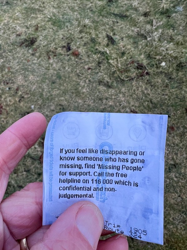
Advice from a bus ticket
 IMG_1506 by Al, on Flickr
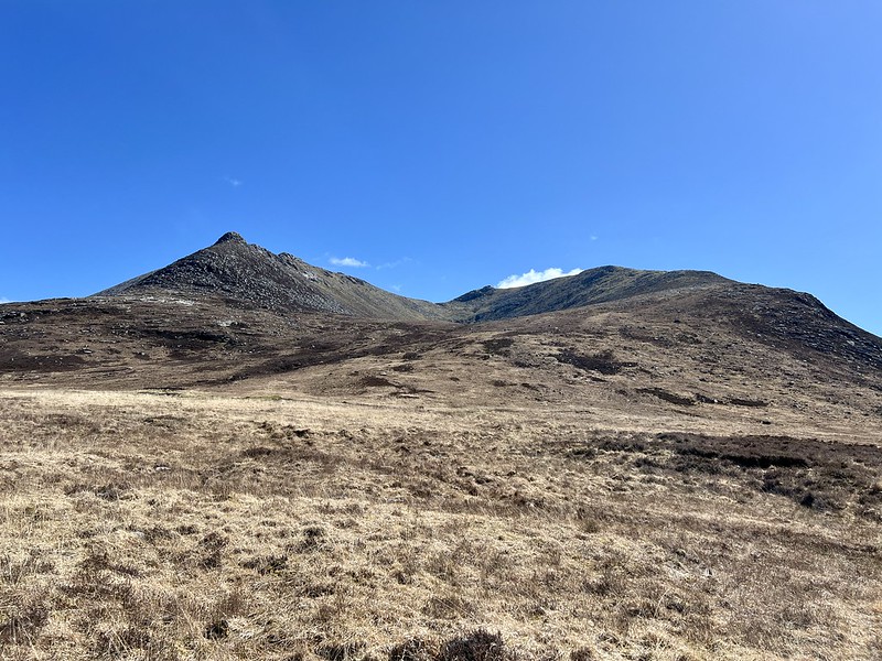
Friday morning was bright and sunny as we packed away the tent and headed off up the glen. Passed a ginormous blue tent looking like something you might have at Everest base camp "hidden" in the trees near the start of the walk. The path is fairly boggy in places, but it's a pleasant amble. We saw this tiny, collarless black dog come racing towards us, out of nowhere, but then its owner appeared. We wandered up to the start of Loch Tanna then started to head obliquely up the hillside, taking animal tracks where they existed and making for the bealach between Beinn Break and Mullach Buidhe, probably the most efficient route to take. Met a group of folk coming down - they looked like Graham baggers - as we eased our way up to the summit.
 IMG_1507 by Al, on Flickr
 IMG_1508 by Al, on Flickr
 IMG_1509 by Al, on Flickr
 IMG_1510 by Al, on Flickr
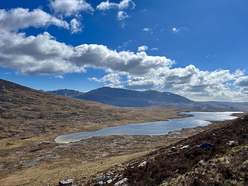
Loch Tanna
 IMG_1511 by Al, on Flickr
 IMG_1514 by Al, on Flickr
 IMG_1515 by Al, on Flickr
 IMG_1516 by Al, on Flickr
Decided to take the WH route down from the top rather than continuing onto the 717m top and descending that shoulder. It's quite steep, initially, and is probably better ascended than descended. Then we made for the track we could see up ahead, forgetting that the route heads down the north of the Allt Ghobhlach - not a major problem, although there is a sign on the bridge saying it's to to be used - we have crossed many bridges in worse states of repair than that one, thank you... We got down to the road just after 3, perfect timing to get the bus from Pirnmill War Memorial at 15.11. But it was 12 minutes late. Still be in time for the 16.40 ferry? Yes, thankfully.
 IMG_1517 by Al, on Flickr
 IMG_1518 by Al, on Flickr
After getting off the busy boat, we drove into Asda car park where we had our tea. Someone had dropped a cucumber then run over it, next to us. A sad and sorry sight. We then had the long drive to Cauldcleuch Head to do. 123 miles, almost 3 hours. I decided to take a route via Dumfries rather than head back to Glasgow, which would have felt too weird, although it would have been a bit quicker. The route via Dumfries actually had us across the border for a few miles which was disconcerting. In the past I've done Caldcleugh Head from the south, at Billhope, but Id drawn a route to do it from Linhope in the west which I thought looked more interesting. There's a large parking area just to the north of Linhope Farm. We arrived in darkness - well there was a bright moon and a clear sky. It was chilly - the car thermometer registered 1.5degrees and the forecast was for freezing temperatures overnight. Just what you want when you have ditched the winter sleeping gear for the lightweight summer stuff We got our kit ready and set off by head torch through the farm buildings, expecting attack dogs to be set on us at any moment. We had no idea where we'd get pitched, but fortunately there's plenty grassy areas along the Linhope Burn and we were maybe 1km from the start when we halted to pitch. Tried to snuggle down to sleep, but it was quite cold overnight.
 IMG_1519 by Al, on Flickr
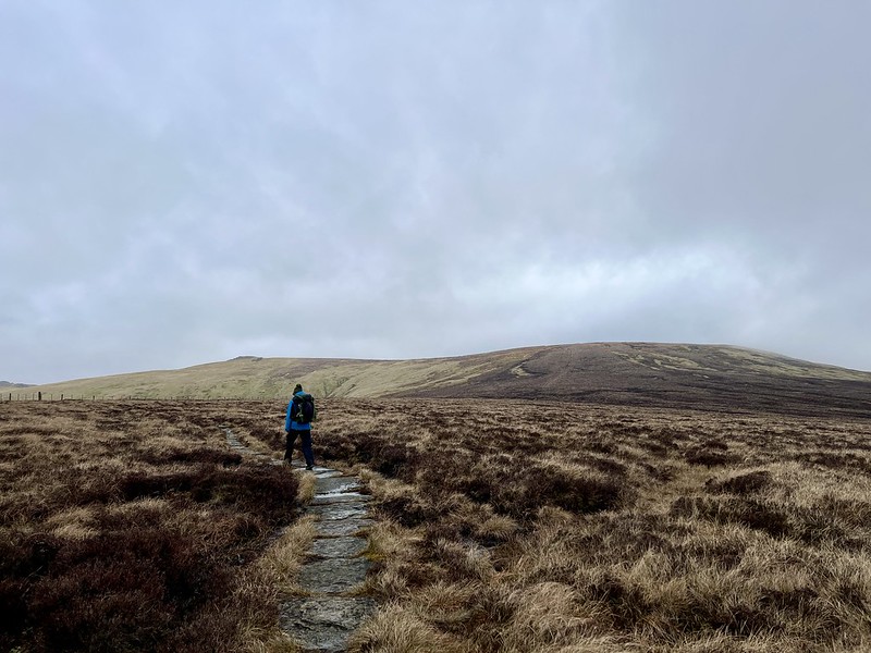
I could have done with longer in bed, but I thought we'd better be up and away before the farm people started coming out and about, so we were set off about 8.30. Track initially, past many heavily pregnant ewes, then up short grass on Jenny's Tongue. Allison had been hoping for track all the way and was underwhelmed with the vague ATV lines up Millstone Edge. Then tussocks before a clearer ATV track runs up the fence line towards Cauldcleuch. We'd dropped our big packs on Langtae Hill which did make the going easier. Not the most dramatic summit in the world - I finished my second round of Donalds here some years ago. We could see over to The Cheviot in the east. Back the way we'd come up, meeting a cheery shepherd on his quad bike, with bespoke crook holder.
 IMG_1521 by Al, on Flickr
 IMG_1522 by Al, on Flickr
 IMG_1523 by Al, on Flickr
It was about 2pm when we got back to the car. Allison had fared reasonably well with the expenditure of effort thus far. I offered her the choice of returning home or heading further east to tick off Windy Gyle and the irritating little bump of Hangingstane Hill. We went for the latter option, although she was hoping we wouldn't have any more ascending to do until tomorrow ...ha!
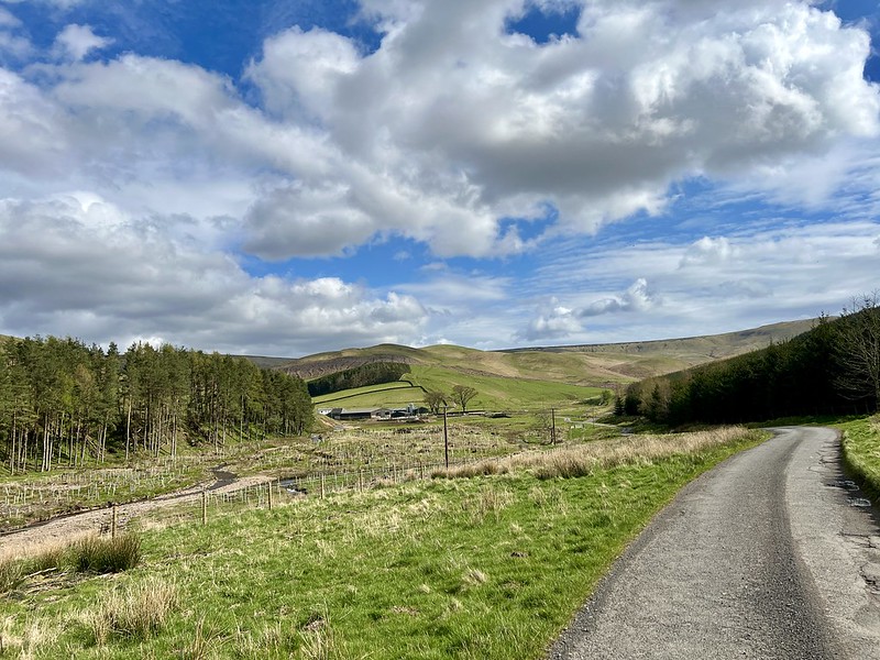
Another 40 miles or so, through Hawick then down twisty roads through Morebattle until we arrived at Cocklawfoot Farm. We parked at a wide forestry opening before the farm itself, though there is grassy parking by the farm entrance. I reckoned we should get up to Windy Gyle and camp there - surprisingly there was to be almost no wind up high tonight. It's a gentle uphill walk, past Kelsocleuch Farm, into some trees then up the short grass of Windy Rig. Some nice flat spots at the summit of Windy Gyle. It was about 6pm by now, time to get the tea on and then retreat into the tent as it was chilly once more.
 IMG_1524 by Al, on Flickr
 IMG_1526 by Al, on Flickr
Windy Gyle
 IMG_1527 by Al, on Flickr
 IMG_1528 by Al, on Flickr
We thought the bottom sign was "angels allowed" but not sure
 IMG_1530 by Al, on Flickr
 IMG_1531 by Al, on Flickr
Bits of rain and what sounded like snow at times overnight. And the boom and crump of the Army firing ranges til dusk then again from first light. We could hear voices as we emerged in the morning - couple of guys and dogs up for a walk. We packed up and walked on the Pennine Way route, mostly paved with limestone slabs. Easy going, just what Allison needed. After a time we came to Hangingstane Hill - not that you'd know it really - it has all of 5m prominence and is only a Donald Top because the border interevenes - actually it's a tiny spur off The Cheviot. But it was duly collected. Each previous time I've been up here I've wanted to do The Cheviot, but haven't as the weather had been crap. We really didn't have that excuse today, mild clag and a little drizzle only. Curlew calls. Quite a lot of people coming up from the east to the summit. We scooped some water out of a boggy puddle for coffee (thankful for the water filter) and sat having lunch at the top.
 IMG_1532 by Al, on Flickr
Hangingstone "Hill"
 IMG_1533 by Al, on Flickr
The Cheviot
 IMG_1534 by Al, on Flickr
Back down over Hangingstane Hill and off down Mallie Side. Path a bit gnarly initially, but opening onto clearer ATV as we descended. Another lengthy drive back through the Borders, heading for Edinburgh. A part of the country I really don't know well at all, and given its lack of significant hills, likely to stay that way. I think A made the right decision to come out this weekend and hopefully we'll be away to the Hebrides as planned from the end of this week.
I had plotted out an audacious route on Mull to link 6 Grahams, the Corbett and some Simms, but this would not classify as an easy route - over 5000m ascent and 75km. No, that one will have to wait. We did have a couple of pesky outliers - Beinn Bharrain on Arran and Cauldcleuch Head down in the Borders - they could be usefully tackled and shouldn't be too demanding. So we headed off to Ardrossan on Thursday afternoon, managed to get on the 6pm ferry. It was a cold and blustery evening, the ferry had been running late all day and I was a little concerned that the 324 bus would leave before we got ashore, but no, all the buses waited docilely in their stances even though we were a wee bit late arriving.
We'd last done Beinn Bharrain two years ago when we did the Arran Coastal Trail, heading up Glen Catacol, and it seemed reasonable to take the same route, which was quite pleasant. We got off the bus at Catacol and made for the gorse bushes by the shoreline, which provided useful shelter from the strong sea breeze. Managed to get a reasonable night's sleep too - seabirds calling, the whoosh of the waves helping rather than hindering.
IMG_1504 by Al, on FlickrIMG_1505 by Al, on FlickrAdvice from a bus ticket
IMG_1506 by Al, on FlickrFriday morning was bright and sunny as we packed away the tent and headed off up the glen. Passed a ginormous blue tent looking like something you might have at Everest base camp "hidden" in the trees near the start of the walk. The path is fairly boggy in places, but it's a pleasant amble. We saw this tiny, collarless black dog come racing towards us, out of nowhere, but then its owner appeared. We wandered up to the start of Loch Tanna then started to head obliquely up the hillside, taking animal tracks where they existed and making for the bealach between Beinn Break and Mullach Buidhe, probably the most efficient route to take. Met a group of folk coming down - they looked like Graham baggers - as we eased our way up to the summit.
IMG_1507 by Al, on FlickrIMG_1508 by Al, on FlickrIMG_1509 by Al, on FlickrIMG_1510 by Al, on FlickrLoch Tanna
IMG_1511 by Al, on FlickrIMG_1514 by Al, on FlickrIMG_1515 by Al, on FlickrIMG_1516 by Al, on FlickrDecided to take the WH route down from the top rather than continuing onto the 717m top and descending that shoulder. It's quite steep, initially, and is probably better ascended than descended. Then we made for the track we could see up ahead, forgetting that the route heads down the north of the Allt Ghobhlach - not a major problem, although there is a sign on the bridge saying it's to to be used - we have crossed many bridges in worse states of repair than that one, thank you... We got down to the road just after 3, perfect timing to get the bus from Pirnmill War Memorial at 15.11. But it was 12 minutes late. Still be in time for the 16.40 ferry? Yes, thankfully.
IMG_1517 by Al, on FlickrIMG_1518 by Al, on FlickrAfter getting off the busy boat, we drove into Asda car park where we had our tea. Someone had dropped a cucumber then run over it, next to us. A sad and sorry sight. We then had the long drive to Cauldcleuch Head to do. 123 miles, almost 3 hours. I decided to take a route via Dumfries rather than head back to Glasgow, which would have felt too weird, although it would have been a bit quicker. The route via Dumfries actually had us across the border for a few miles which was disconcerting. In the past I've done Caldcleugh Head from the south, at Billhope, but Id drawn a route to do it from Linhope in the west which I thought looked more interesting. There's a large parking area just to the north of Linhope Farm. We arrived in darkness - well there was a bright moon and a clear sky. It was chilly - the car thermometer registered 1.5degrees and the forecast was for freezing temperatures overnight. Just what you want when you have ditched the winter sleeping gear for the lightweight summer stuff
IMG_1519 by Al, on FlickrI could have done with longer in bed, but I thought we'd better be up and away before the farm people started coming out and about, so we were set off about 8.30. Track initially, past many heavily pregnant ewes, then up short grass on Jenny's Tongue. Allison had been hoping for track all the way and was underwhelmed with the vague ATV lines up Millstone Edge. Then tussocks before a clearer ATV track runs up the fence line towards Cauldcleuch. We'd dropped our big packs on Langtae Hill which did make the going easier. Not the most dramatic summit in the world - I finished my second round of Donalds here some years ago. We could see over to The Cheviot in the east. Back the way we'd come up, meeting a cheery shepherd on his quad bike, with bespoke crook holder.
IMG_1521 by Al, on FlickrIMG_1522 by Al, on FlickrIMG_1523 by Al, on FlickrIt was about 2pm when we got back to the car. Allison had fared reasonably well with the expenditure of effort thus far. I offered her the choice of returning home or heading further east to tick off Windy Gyle and the irritating little bump of Hangingstane Hill. We went for the latter option, although she was hoping we wouldn't have any more ascending to do until tomorrow ...ha!
Another 40 miles or so, through Hawick then down twisty roads through Morebattle until we arrived at Cocklawfoot Farm. We parked at a wide forestry opening before the farm itself, though there is grassy parking by the farm entrance. I reckoned we should get up to Windy Gyle and camp there - surprisingly there was to be almost no wind up high tonight. It's a gentle uphill walk, past Kelsocleuch Farm, into some trees then up the short grass of Windy Rig. Some nice flat spots at the summit of Windy Gyle. It was about 6pm by now, time to get the tea on and then retreat into the tent as it was chilly once more.
IMG_1524 by Al, on FlickrIMG_1526 by Al, on FlickrWindy Gyle
IMG_1527 by Al, on FlickrIMG_1528 by Al, on FlickrWe thought the bottom sign was "angels allowed" but not sure
IMG_1530 by Al, on FlickrIMG_1531 by Al, on FlickrBits of rain and what sounded like snow at times overnight. And the boom and crump of the Army firing ranges til dusk then again from first light. We could hear voices as we emerged in the morning - couple of guys and dogs up for a walk. We packed up and walked on the Pennine Way route, mostly paved with limestone slabs. Easy going, just what Allison needed. After a time we came to Hangingstane Hill - not that you'd know it really - it has all of 5m prominence and is only a Donald Top because the border interevenes - actually it's a tiny spur off The Cheviot. But it was duly collected. Each previous time I've been up here I've wanted to do The Cheviot, but haven't as the weather had been crap. We really didn't have that excuse today, mild clag and a little drizzle only. Curlew calls. Quite a lot of people coming up from the east to the summit. We scooped some water out of a boggy puddle for coffee (thankful for the water filter) and sat having lunch at the top.
IMG_1532 by Al, on FlickrHangingstone "Hill"
IMG_1533 by Al, on FlickrThe Cheviot
IMG_1534 by Al, on FlickrBack down over Hangingstane Hill and off down Mallie Side. Path a bit gnarly initially, but opening onto clearer ATV as we descended. Another lengthy drive back through the Borders, heading for Edinburgh. A part of the country I really don't know well at all, and given its lack of significant hills, likely to stay that way. I think A made the right decision to come out this weekend and hopefully we'll be away to the Hebrides as planned from the end of this week.
Click to mark this as a great report. Register or Login free to be able to rate and comment on reports (as well as access 1:25000 mapping).
Heatwaves and blizzards in the North East
Fionas: Beinn Tharsuinn (Ardross), Creag Mhór (Balquhidder), Meall Mór (Easter Ross)
Date walked: 14/04/2024
Distance: 50km
Ascent: 2240m
Views: 286
Big Winds in Ardgour
Date walked: 07/04/2024
Distance: 47km
Ascent: 2355m
Views: 265
Easter in Alladale - plus a remote bothy visit.
Fionas: Beinn Tharsuinn (Deanich), Càrn a' Choin Deirg, Càrn Salachaidh, Meall a' Chaorainn (Easter Ross)
Date walked: 01/04/2024
Distance: 85km
Ascent: 3307m
Comments: 3
Views: 389
Some Grahams around Perthshire
Date walked: 24/03/2024
Distance: 61km
Ascent: 2714m
Views: 308
Bagging around Cannich
Fionas: Beinn a'Mheadhoin, Càrn Gorm
Date walked: 17/03/2024
Distance: 40km
Ascent: 2695m
Views: 319
Ice Cold on Vurich
Fionas: Creag a'Mhadaidh
Date walked: 10/03/2024
Distance: 61km
Ascent: 1950m
Views: 423
Out of Puff in Ardgour
Fionas: Glas Bheinn (Kinlocheil), Meall nan Damh, Stob Mhic Bheathain
Date walked: 03/03/2024
Distance: 38km
Ascent: 2240m
Views: 434
Skye Mountain Magic
Sub 2000s: Sgùrr na Strì
Date walked: 25/02/2024
Distance: 47km
Ascent: 2275m
Comments: 4
Views: 763
Remote Grahams, Bothy Nights
Date walked: 18/02/2024
Distance: 44km
Ascent: 2000m
Comments: 6
Views: 1010
-
weaselmaster
- Location: Greenock
- Occupation: Idle and old
- Interests: Searching for meaning
- Activity: Hill Bagger
- Mountain: Foinaven
- Place: Assynt and beyond
- Gear: Satmap Active 12
- Member: MCofS MBA JMT RHB
- Camera: iPhone 13 / Sony RX100
- Ideal day out: One that lasts at least 72 hours...
- Munro rounds: 2
- Corbett rounds: 2
- Fiona rounds: 2
- Donald rounds: 2
- Munros: 277
- Tops: 221
- Corbetts: 217
- Fionas: 197
- Donalds: 75+31
- Wainwrights: 15
- Hewitts: 33
- Sub 2000: 391
- Islands: 28
- Long Distance routes: West Highland Way Cape Wrath Trail
- Filter reports
- Trips: 15
- Distance: 813 km
- Ascent: 38436m
- Corbetts: 11
- Fionas: 40
- Donalds: 35
- Sub2000s: 1
- Trips: 51
- Distance: 3123.8 km
- Ascent: 151785m
- Munros: 12
- Corbetts: 54
- Fionas: 163
- Donalds: 19
- Sub2000s: 9
- Hewitts: 2
- Trips: 53
- Distance: 3136.5 km
- Ascent: 155385m
- Munros: 59
- Corbetts: 65
- Fionas: 92
- Donalds: 8
- Sub2000s: 2
- Trips: 43
- Distance: 2399 km
- Ascent: 129611m
- Munros: 135
- Corbetts: 62
- Fionas: 25
- Sub2000s: 8
- Trips: 60
- Distance: 1982.7 km
- Ascent: 85039m
- Munros: 13
- Corbetts: 2
- Fionas: 8
- Donalds: 2
- Sub2000s: 190
- Trips: 57
- Distance: 2933 km
- Ascent: 180392m
- Munros: 11
- Corbetts: 193
- Fionas: 34
- Donalds: 1
- Sub2000s: 27
- Trips: 61
- Distance: 3090.77 km
- Ascent: 206176m
- Munros: 271
- Corbetts: 16
- Fionas: 10
- Donalds: 9
- Sub2000s: 32
- Trips: 76
- Distance: 2994.86 km
- Ascent: 175243m
- Munros: 67
- Corbetts: 12
- Fionas: 72
- Donalds: 81
- Sub2000s: 97
- Hewitts: 13
- Wainwrights 12
- Trips: 78
- Distance: 2035.42 km
- Ascent: 124390m
- Munros: 18
- Corbetts: 5
- Fionas: 142
- Donalds: 71
- Sub2000s: 24
- Hewitts: 15
- Trips: 68
- Distance: 2453.94 km
- Ascent: 164961m
- Munros: 77
- Corbetts: 126
- Fionas: 17
- Donalds: 8
- Sub2000s: 2
- Trips: 64
- Distance: 2406.7 km
- Ascent: 166291m
- Munros: 109
- Corbetts: 112
- Fionas: 16
- Donalds: 10
- Trips: 64
- Distance: 1894.46 km
- Ascent: 127277m
- Munros: 219
- Corbetts: 17
- Fionas: 4
- Donalds: 3
- Sub2000s: 1
- Trips: 24
- Distance: 254.33 km
- Ascent: 16304m
- Munros: 26
- Corbetts: 5
- Trips: 1
- Corbetts: 1
- Donalds: 1
- Joined: Aug 22, 2012
- Last visited: Apr 23, 2024
- Total posts: 2436 | Search posts