
Summary
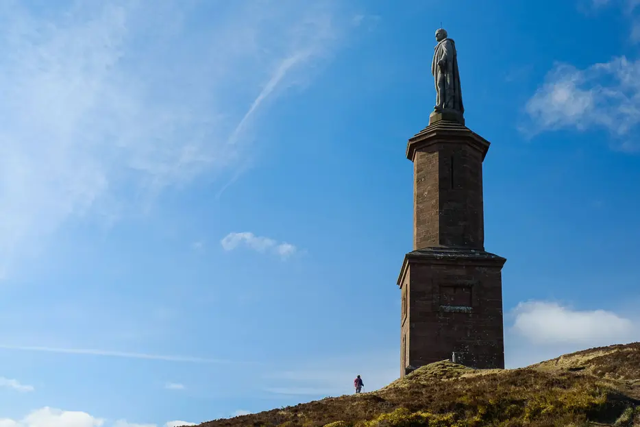
The steep pull up Ben Bhraggie (or Beinn a'Bhragaidh to give it its proper, Gaelic name) is well rewarded by excellent views over the coastline and inland hills - on a clear day both coasts of Scotland can be seen. The massive Sutherland monument, locally known as the 'The Mannie', marks the top from where this circuit takes a gentler route down on forest tracks initially. The circuit is then extended by returning down the dramatic Big Burn gorge.


Terrain
Waymarked footpaths and tracks.
Getting there
Start
Car park just off Golspie main street on Fountain Road.
Public Transport
Golspie train station is at the west end of the village.
Start Grid Ref
NH832999

Stage 1
Start from the centre of Golspie, where Fountain Road meets the main street - there is a car park here with toilets. Begin the walk by heading up Fountain Road, past the ornate fountain and straight across the junction to go under the railway line and continue up the road. Ignore the car park off to the right (used for the bike trails) and continue up the road to Rhives Farm. Take the new gravel path to the right of the farm buildings then veer right just beyond the farm, signed Ben Bhraggie.

Stage 2
The track curves right towards the woods, reaching a junction. Take the narrow track that heads off left here - signed for Ben Bhraggie. This climbs diagonally along the bottom of the forest. Pass a tall gate, and look out for a path waymarked on the right (blue arrow) that cuts a corner. When this rejoins the woodland track follow it uphill ahead. Turn right at the next junction (signed Ben Bhraggie).

Stage 3
This path soon reaches a main forestry track. Turn right and then immediately left to continue up the Ben Bhraggie path, soon leaving the mature trees and heading up though an area of new plantings. Looking back, superb views open up over Golspie and the coastline now far below. Eventually a huge wooden mountain bike feature is reached; go up steps and take the path that heads through a gate underneath this feature and continue on the path up the moorland beyond.

Stage 4
Continue on the path as it heads towards the Sutherland monument which soon looms into view; it is hard to grasp the scale of it unless there are other walkers at the base. The 100 foot statue is on of George Granville Leveson-Gower, the first Duke of Sutherland, notorious for his role in the forced clearances of his tenants to make way for sheep in the early nineteenth century. After his death in 1833, money for the statue was raised by subscription and the stone was quarried nearby and the statue brought up by horse and cart in pieces. More recently some campaigners have called for the monument to be removed but many locals beleive it should remain to remind of his role in the clearances.

Stage 5
Ben Bhraggie is a corruption of the original Gaelic name Beinn a'Bhragaidh; the views up and down the east Sutherland coastline are unmatched. From the base of the monument follow the track heading inland passing a small pool and then a sheltered wooden bench.

Stage 6
The track curves across the heather moorland with good views in all directions - Ben Klibreck is prominent - and a windfarm visible to the north. Ignore tracks off on either side, heading into the forest and straight across at a crossroads. Eventually a path junction is reached - the route waymarked to the right for Golspie is the quickest way back, rejoining the outward route at Rhives Farm. If you have the energy, however, keep straight on to make the return via Big Burn as described below.

Stage 7
At the next junction turn left onto a path shared with mountain-bikers - signed as the Big Burn link trail. This winds through the trees before eventually emerging on a minor road. Turn left here, crossing the bridge, and then immediately right onto the lower of two paths running along the far side of the garden of the house. Soon a muddier path forks right and continues down the near side of the river, rejoining the main path a short distance further on (do not cross the bridge). At the next junction with a bench turn right to cross a footbridge. This gives views down onto Big Burn falls, and continues with a railing before descending steeply to the lower river. Turn right at the bottom to begin the walk down the most impressive part of the gorge, crossing several bridges.

Stage 8
Once over the last bridge follow the well-made made which continues down the left side of the Big Burn, ignoring branches off to the left. Eventually the path leads under a high railway viaduct, and then crosses an arched wooden footbridge. Continue through the parking area to reach the main A9 road, and then turn right along the pavement to head back through Golspie until the Fountain Road turning and the start.

Route Profile
