Summary
With its summit just a short distance from the Southern Upland Way, Minch Moor makes for a popular short hillwalk from Traquair, with great views. The alternative return route described is rougher underfoot and requires more careful navigation.
Grade

Bog Factor

Rating
Distance
Time
(in summer)
Ascent
Terrain
Southern Upland Way provides excellent walking conditions up to near the summit, from where a good path leads to the cairn. Alternative descent route is rougher, unmarked and can be wet in places.
Are you REALLY ready for winter hills?
Hillwalking when there is snow lying requires an ice-axe, crampons and knowledge of how to use them safely. The description here is for summer conditions.
See our Winter Skills page for basic information on the essential skills, techniques and knowledge needed for winter.
Getting there
Start
Community hall car park, Traquair.
Public Transport
None to start; nearest bus at Innerleithen, 3km away.
Start Grid Ref
NT331345
Summits Climbed
- Sub 2000
- Minch Moor

Stage 1
Park in the community hall car park in Traquair (turning off at the war memorial). The walk begins by continuing along the lane, following the route of the Southern Upland Way. Further up the lane, keep on the unsurfaced lane ahead (Minch Moor sign) when the tarmac goes right into a driveway, and keep ahead again onto a rougher track at the last house. The track leads though a gate and eventually curves left.

Stage 2
After passing through another gate the Southern Upland Way track reaches an old stone gateway decorated with many slate plaques commemorating horses, some with poems. Continue ahead, going straight on when the Way reaches a large track running across the route. The route then meets a second track, with two paths continuing opposite; take the right hand path, still signed as the Southern Upland Way.

Stage 3
Further up the path joins a larger track and reaches a viewpoing over 'Resolution Point' - once an art installation, now fading shapes in the heather. Continuing ahead, the path next reaches the Cheese Well - a natural spring which has long been a water source for travellers on this old drove route - it was marked on Timothy Pont's map of 1600. Wayfarers often left offerings here - including cheese - to thank the faeries for their safe passage.

Stage 4
At the next junction, at the corner of forestry (and also with a seat) turn right onto a path signed for Minch Moor. Ignore the mountain bike path heading off to the right and continue to reach the summit - marked with a trig point and a small stone cairn. On a good day this is a fine viewpoint.

Stage 5
The quickest and much the easiest return route is to retrace your steps. Another option is to head down the mountain bike route to the right (bikers ascent via this route and so are easy to let pass) - but this route is very winding. A third option is to continue ahead in the original direction on a much narrower path. This descends into a wide gap between blocks of forestry, soon accompanied by a stone wall. Ignore the first trace of a path to the right (which almost immediately joins the MTB route), continuing ahead until there is a narrow ride heading into the trees on the right, with occasional wooden posts - this is an old route known as the 'Clattering Path'. The narrow path gives muddy going; when it forks ignore the uphill branch to the right, bearing slightly left and reaching a felled area. The path continues across this and re-enters forestry, soon joining a clearer path coming down from the right. Further on the MTB track is met at a bend - keep ahead, slightly downhill. Eventually this emerges onto a track. Turn right and then left to stay on the MTB route.

Stage 6
After some zig-zags this reaches a track - go straight across to rejoin the Southern Upland Way opposite. From here simply retrace your steps downhill to eventually return to the start.

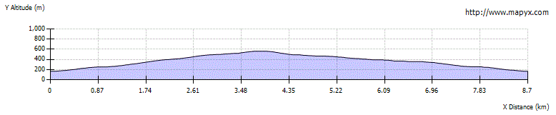
Route Profile