Summary
Explore a delightful cross section of Borders farmland and open moor on this linear route from Peebles to Broughton named after the famous author who had associations with the area.


Terrain
Minor road, tracks, good paths on open moorland and farmland.Minor road, tracks, good paths on open moorland and farmland.
Getting there
Start
Peebles.
Public Transport
Bus links Broughton with Peebles for return.
Start Grid Ref
NT251402

Stage 1
The route is signed with a book logo with JBW. Peebles High Street houses the John Buchan Story where you can learn more about the extrordinary life of the prolific writer, author of The 39 Steps and over a hundred other books, one time MP, editor of The Spectator and finally Goveror General of Canada, he spent many family holidays in the area and siblings who lived in Peebles. The walk starts at Bank House (once a Buchan family home), at the far west of Peebles High Street and turns left to cross the bridge over Tweed. Keep on the right hand side of the bridge and on the far side head onto Caledonian Road but immediately cross the road to head uphill straight ahead between houses and continue up the alleyway which winds up to reach Chambers Terrace, turn right here and take the next left to follow another pathway next to Frankscroft which soon runs alongside school playing fields.

Stage 2
Cross the road ahead and turn right onto the path which skirts the edge of more playing fields and through trees alongside Craigerne Lane. At the end of the path turn left to follow the minor road gently uphill and before the house entrance turn right through the metal gate and continue uphill alongside a wall. After a gate continue up more open ground keeping to the right hand path aiming for Cademuir Hill. There are good views back to Peebles with the large white Hydro Hotel dominating the landscape. The path soon contours the west side of the slope, keep straight ahead at a waymarked fork still aiming for Cademuir Hill, the lumps of the remains of the hill fort now visible. At the next path junction turn right to go through the centre of the ancient fort and to get superb views. The path soon curves left to start heading south.

Stage 3
Go straight across at the next path junction to head down towards a wall, the path running along the right hand side. Eventually the path runs past a small Scots pine plantation and reaches the road. Turn right either just before the road, to take the grassy path which runs parallel to it, or just follow the road to pass the entrance to Cademuir Farm. The road descends passing a couple of cottages to reach picnic tables next to Manor Water. Cross the bridge and at the next road junction turn left to head up The Glack. Dog leg slightly left here and take the signed path between two houses soon going through a farm gate and following a grassy (sometimes muddy) track gently uphill.

Stage 4
Once through another gate the route continues on the rough and indistinct track heading uphill eventually reaching a stile at a stone wall. Follow the path straight ahead as it contours round the hill with the wall and fence on your right. Head downhill at the corner of the fence with good views over Tweedsdale once more. The path descends boggy ground to cross a footbridge over a burn and climbs up to a track, turn right to descend towards Easter Dawyck farm going through a wooden gate. Immediately after a metal farm gate turn left to follow the fence and then wall to avoid the farm. A small gate leads into the next field, keep to the edge, soon heading downhill with a stone wall on your left. A stile leads to the farm access track, turn left along this to soon reach a bridge over the Tweed.

Stage 5
After the bridge turn right along the B712 for a short section to Stobo the half way point of the walk. Stobo Kirk which may date from 1120 is a short detour to the left and has a stained glass window showing Merlin being baptised by St Mungo. After the phone box turn left opposite the bus stop (signed 'John Buchan Way') and follow the lane. After the last cottage go over the stile on the left and follow the grassy track alongside the Easton Burn. After a gate, with a bridge on your left turn right onto another track and continue by the burn, passing a sheep fank. Keep left when the track forks and left again at another fork, aiming to the left of a fir plantation. Over a stile the track continues to a ruin, bear left here over a small footbridge, soon reaching a wooden farm gate at some pine trees with the track leading onto open moor.

Stage 6
The next section has a fantastic remote feel although it is only a few miles from Broughton and Stobo. The track climbs uphill with views to Penvalla and Broughton Heights coming into view as the route rises. Keep right at a waymarker to descend to a footbridge over Hopehead Burn. The path leads up to a track, turn right along it soon approaching the remote house at Stobo Hopehead. Just before the house branch left, soon turning left onto a path which soon starts to climb towards the clear gap in the hills ahead. Look out for the unusual hexagonal stone sheep pen (or stell) on the right.

Stage 7
The path is rough and can be boggy in places. The path continues after the stile at the saddle of the hills, soon turn left at a clear path junction to descend towards Broughton (the path to the right can be used to climb Broughton Heights). The wide grassy track follows Hollows Burn before eventually crossing it on a small footbridge and climbing towards the trees soon going through a gate and reaching the cottage and former parking area.

Stage 8
Continue ahead passing Broughton Place which looks like an ancient Borders castle but was in fact designed in 1938 by the architect Basil Spence. Follow the road past Broughton Place Farm, keeping ahead downhill. The road doglegs to the right of a farmyard before continuing down to reach the main A701 road. Cross and turn left soon reaching the pavement and the cottages of Broughton, which has a shop, tearoom and brewery. The bus stop is near the junction with the B7016.

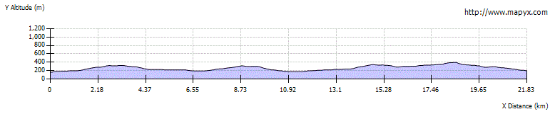
Route Profile