
Summary
Papa Westray is one of the smaller and more remote islands of Orkney, but it is packed with interest. This full coastal circuit of the island takes in northern Europe's oldest standing house, one of northern Scotland's most ancient churches, sandy beaches, rocky cliffs and spectacular colonies of seabirds. The walk be can shortened by cutting across the island at several points. In the summer months there are several ferries a day to Moclett Pier from Gill Pier near Pierowall on Westray, enabling the walk to be done in a day visit from the larger nearby island. Out of season there are fewer ferries and a day visit may be reliant on using a flight between the two islands - the shortest in the world.


Terrain
Mostly grassy coastal path, faint in places but all fences have stiles. Some rougher sections.
Getting there
Start
Moclett ferry pier.
Public Transport
Papa Westray can be reached by ferry or air.
Start Grid Ref
HY494493

Stage 1
Leaving Moclett pier, turn right through a gate onto a track to begin the walk around the coastline in an anti-clockwise direction. At a fork keep right on the coastal track, following it until it ends at an old quarry. From here the walk continues as a grassy footpath, crossing two walls and a fence at well-built stiles. Pass around the back of the Bay of Burland. From the far end of this you can either continue on the coast, or take a detour to visit the ruins of St Tredwall's Chapel. For the latter, follow a grassy track that cuts north from the far end of the Bay of Burland and then leave it across pathless ground aiming for a gateway in the wall to the west. Pass through this and then keep to the left of a fenceline that leads to the chapel ruins on a promontory in the Loch of St Tredwall.

Stage 2
The chapel has now completely collapsed, but was once a centre of pilgrimage, said to have healing properties for people with eye complaints. It is built on an artificial promontory atop Iron Age remains, including an underground passage (not accessible). Rather than retrace your steps to the coast path, cross a stile and head northeast with a fence on your left - parallel to the loch. At a wall cross another stile and continue in the same direction, keeping to the right of a wall. After passing through a gap the coast path is soon rejoined. Near Links leave the coast and instead follow the grassy track as it swings inland to the left. Pass through a gate and follow the track as it bends right. At a junction keep straight ahead on a road. This soon returns to the coast near a pier - follow the track left past a finely built stone house.

Stage 3
Keep on the track past some old traditional houses with massive stone roof slabs. The track runs behind the sandy bay of South Wick, with the island of Holm of Papa just offshore - the top of its chambered tomb prominent. Soon the track joins a road again, continuing by the coast and passing more houses. Soon the larger sand bay of North Wick is reached. When the road turns left inland, instead turn right on a track to stay by the coast. When the last house at Ness is approached it is easiest to take to the sandy beach.

Stage 4
From the north end of the beach take to the grassy shore, passing between the sea and the tiny Loch of Ness. Seals can often be seen hauled up on Weelie's Taing, whilst this whole coast has a large population of eider ducks. It's easiest to pass the large complex of old sheepfolds on the left side before rejoining the coast again, which is now starting to rise towards the cliffs of Fowl Craig. Cross a stile over a fence to enter the RSPB North Hill reserve. Ignore the stile over a wall on your left and instead continue the walk along the fine clifftops. There are good views if you take care of the breeding colonies of black guillemots - locally known as tysties. A short distance further on a stone plynth is reached with a model of a great auk - the last of these amazing metre high birds - also known as the Northern Penguin - was shot here for a collector in 1813.

Stage 5
Further on cross a stile over the last stone wall to reach the open northern part of the island. The cliffs start to lose their height, but there are fine displays of flowers in the summer as well as impressive wave-cut platforms; the position of the island means that the seas are often particularly wild here - especially at Fowl Flag at the northernmost tip. Pass a stone cairn and continue around Mull Head before beginning the walk back down the western side of the island. Great rocky slabs slope into the sea at a gentler angle on this side, but this part of the island is enlivened by its great colonies of terns which breed here in the summer - often defending their open nests very aggressively!

Stage 6
Eventually a massive stone wall is reached - cross this on the stile near the seaward end. Now continue along the coast, crossing further stiles before reaching St Boniface Kirk - which can be visited by a short detour to the left. The restored kirk is located on an important religious site dating back to the 8th century, and is the only Orkney Church apart from St Magnus Cathedral to survive the reformation and still be in use today. The churchyard houses a rare Norse hog-back gravestone as well as more recent memorials to those lost in shipwrecks in the surrounding waters.

Stage 7
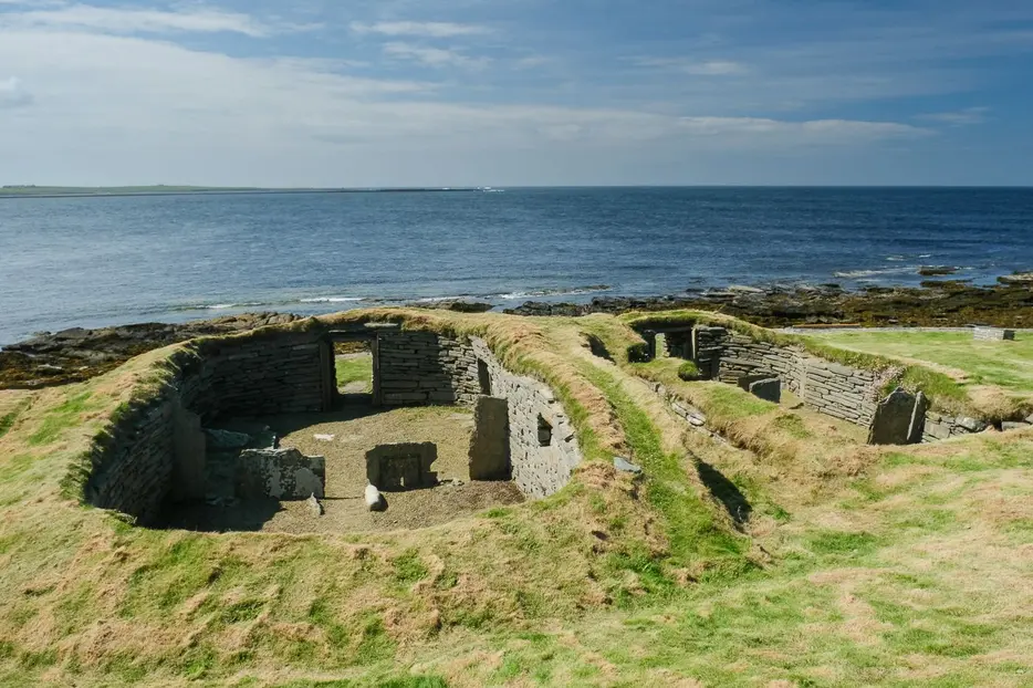
Retrace your steps to the coast and then follow the shoreline south over farmland and through a gate to eventually reach the remarkable Knap of Howar. Enclosed by a fence, the entrance to this site is on the landward site. A spectacularly preserved neolithic farmstead dating back to 3800BC, the Knap is thought to be the oldest North European dwelling house to still be largely standing. The buildings can be entered via low passages to reveal stone furniture including benches and storage shelves. Although it's possible to continue by the coast, our route leaves the coast here to follow an initially grassy track that heads inland diagonally across the field.

Stage 8
This passes through a gate and continues as a track to reach the large complex of buildings that make up the farmstead of Holland - one of the most complete traditional farmsteads on Orkney. One of the buildings on the left houses the bothy museum which is well worth a look inside for a glimpse into past life on the island. Papa Westray's community shop and hostel are at Beltane around 300m east from here, but our route turns right to follow the main island road south, passing the fire station, and then turns right at a junction by an old cottage. This leads back to the coast, continuing as a track to the farm at Whitehowe. From here resume the coastal walk on a grassy track; all walls and fences have stiles.

Stage 9
Where there is both a gate and stile take the stile to go on the seaward side of the fence - the next section can be overgrown in summer and you may decide to take to the shoreline for sections. The overgrown stretch is short, however, and soon grassy trods lead around the southernmost point of Papa Westray - Vest Ness. Pass around this and then cross a stile to walk back up the east side of this peninsula. Eventually the fine sandy beach at the back of the Back of Moclett is reached - a great place to kill any spare time before your return ferry. From the far end of the beach pick up the road to head back to Moclett ferry pier - there are public toilets and a waiting room if needed.

Route Profile
