
Summary
Beinn Eighe is the bulkiest of the trinity of great Torridon peaks. The western half of its ridge contains both of its two Munros. This section of the ridge makes a fine traverse with magnificent views; it may involve less scrambling than Beinn Alligin or Liathach, but compensation comes when Coire Mhic Fhearchair is reached during the descent; this is the most spectacular of all Torridon's corries.
Grade

Bog Factor

Rating
Distance
Time
(in summer)
Ascent
Terrain
A well-walked route; there is a clear but steep path up to the ridge, which is rocky and rough, with some mild scrambling. The descent to Coire Mhic Fhearchair is down a very steep and eroded scree chute requiring great care. From the lochan, a good stalkers path leads back to the start.
Are you REALLY ready for winter hills?
Hillwalking when there is snow lying requires an ice-axe, crampons and knowledge of how to use them safely. The description here is for summer conditions.
See our Winter Skills page for basic information on the essential skills, techniques and knowledge needed for winter.
Getting there
Start
Car park just west of the bridge over the Allt a Choire Dhuibh Mhòir.
Public Transport
None to start.
Start Grid Ref
NG958569
Summits Climbed
- Munro
- Ruadh-Stac Mòr
- Munro
- Spidean Coire nan Clach
Stage 1
This classic circuit is described clockwise in most guides but the steep screes above Coire Mhic Fhearchair are marginally more tolerable if taken in descent, so an anti-clockwise circuit may be preferred. Park in the Coire Dubh car park, but ignore the signed path for Coire Mhic Nobuil (used on the return route) and instead begin by walking 2km east along the road. Turn left on the track to the parking area at Coire an Laoigh, which is an alternative start / parking point (leaving the short road walk until the end). A cairn marks the start of the footpath up towards Coire na Laoigh.

Stage 2
The path climbs gently at first up the grassy slopes before steepening as it climbs up towards the corrie between the main ridge and the projecting spur of Stùc Coire an Laoigh. Great views open up looking back across Loch Bharranch to Sgùrr Dubh and the mountains of the Coulin Forest.

Stage 3
Much higher up the path reaches the grassy floor of Coire an Laoigh for a brief respite before beginning a very steep climb up the headwall to reach the ridge between Stùc Coire an Laoigh and Beinn Eighe itself. At this point there is a large cairn and a stunning sudden view ahead of Liathach - looking like an unassailable battleship. Turn right to continue the ascent, with the path winding its way up a mass of quartzite scree.

Stage 4
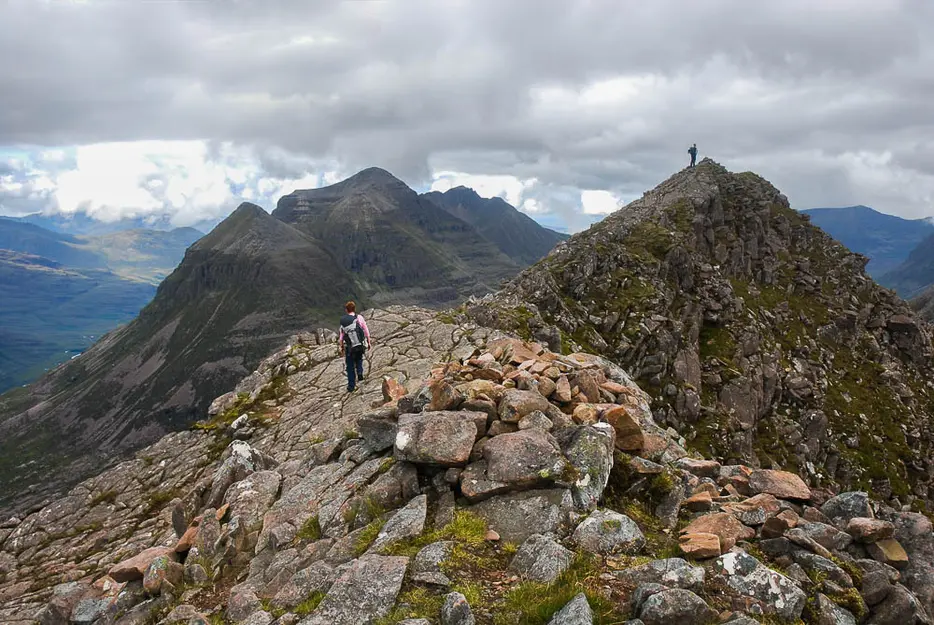
The main ridge is gained at an Ordnance Survey trig point at 972 metres. In misty conditions with careless navigation this could be mistaken for the first Munro of the day, Spidean Coire nan Clach, but in fact the summit involves a detour along the ridge to the right. The crest is narrow and composed of quartzite, but a path leads along to the true summit, bypassing a rocky outcrop along the way. Shortly before the top there is a mild scramble up a quartzite staircase which could be slippery if the rocks are wet. Once at the tiny cairn, there is a fine view over the eastern summits of Beinn Eighe. These are not classed as separate Munros but are fine summits linked by airy ridges including the notorious Black Carls pinnacles, and are well worth a days outing in their own right.

Stage 5
Return to the trig pillar and this time continue along the ridge to the west. The quartzite stones soon give way to a slabby sandstone crest that gives firmer going to a minor top before the stones return on the descent to a bealach at 820 metres.

Stage 6
The bealach and the climb beyond is uncharacteristically grassy and gentle, with great views back on the way up to the flat summit of Coinneach Mhor; in fact the top of the Triple Buttress, one of Scotland's finest cliffs, is only a short distance away to the west. From the cairn descend the steep and stony ridge to the narrow bealach which separates Ruadh-stac Mhòr from the main ridge of Beinn Eighe.

Stage 7
The first part of the climb up to Ruadh-stac Mhòr is very rocky and rough but soon becomes easier on a plateau before the final short pull up the summit scree-cone. Although not on the main ridge, this is the highest of Beinn Eighe's summits, and its detached position makes it a fabulous viewpoint for most of the range. Return to the bealach between the top and Coinneach Mhor. There is only one way down to the floor of Coire Mhic Fhearchair for non-climbers, and that is down the very steep and narrow scree gully heading northwest from here. Take great care on the descent, keeping to the right edge of the scree as the bedrock is exposed in places making a rocky staircase - though keep an eye out for loose rocks. The gully narrows at one point where it is almost blocked by a chockstone which is passed on the right.

Stage 8
Continue down the right edge of the scree until below the broken cliffs, where a path continues the descent northwest between the scree and the bottom of the cliffs. Descend on this path until it too heads left down the lower section of scree; finally pick your way down the steep boulders to reach the flatter ground below. You are now below the screes but there is still some way to go before the easier terrain at the bottom of the corrie is reached. Head over to the left to pick up a path that continues the descent, staying fairly close to the bottom of the cliffs on the south side of the corrie. The path picks its way down several sandstone terraces and descends past some beautiful little pools and waterfalls to reach Lochan Coire Mhic Fhearchair.

Stage 9
Continue on the path round the eastern shores of this beautiful lochan. Behind you is the magnificent Triple Buttress, seen to best effect when the far end of the lochan is reached. The exit stream from the lochan is a very popular spot for walkers coming up the path from Glen Torridon, with its classic view across the water to the masterpiece of rock architecture beyond. Cross the outflow from the loch to pick up an excellent stalkers path. This descends round the lower slopes of Sàil Mhòr - with views back of some attractive waterfalls below the loch outflow - contouring right round the base of the peak and offering fine views into the wild country behind Torridon. The path is rocky but very well constructed, and eventually leads to a large cairn at a junction with a path from Coire Mhic Nobuil. Keep left, on the main path, to descend Coire Dubh Mòr , and eventually return to the A896.

Route Profile
