Summary
A mixed stage with farmland, high moorland and big forests. The route now takes a high level option in the first half although a lower alternative on easier forest tracks can be followed if preferred or in poor weather. 8km of road walking along the Ettrick valley has pleasant views and is followed by a dramatic hill section at Ettrick Head to finish at lovely St Mary's Loch.
Grade

Bog Factor

Rating
Distance
Time
(in summer)
Ascent
Terrain
Mostly good paths, tracks and roads. Care with navigation is needed on the high moorland sections in poor visibilty.
Are you REALLY ready for winter hills?
Hillwalking when there is snow lying requires an ice-axe, crampons and knowledge of how to use them safely. The description here is for summer conditions.
See our Winter Skills page for basic information on the essential skills, techniques and knowledge needed for winter.
Getting there
Start
Beattock.
Public Transport
Bus at Beattock, no bus at St Mary's Loch.
Start Grid Ref
NT077028
Summits Climbed
- Fiona / Donald
- Croft Head

Stage 1
From Beattock head back north towards the motorway junction, or turn left where the SUW comes down to join the road into Beattock. Just before the roundabout turn right to cross the road and take a signed path ahead. This follows the north side of the Evan Water, heading under the concrete bridges of the M74 to reach a minor road. Turn right along this. The Annandale Way path off left offers the quickest route if you wish to detour to Moffat, otherwise continue ahead. After Barnhill Springs cross the River Annan to reach a T junction. Go straight ahead here onto a path which crosses the hillside before joining a road beside the Moffat Water. Turn left along the road and then turn right over a bridge at the next junction. Almost immediately turn left at a stile into the mature beech trees of Dumcrieff Wood. Follow the main path through the wood, eventually crossing a burn and leaving the trees to keep to the bank of Moffat Water through fields. Eventually a stile leads to another minor road.

Stage 2
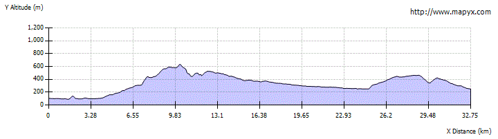
Cross the road (but not the bridge) to take the track ahead which soon leaves the river and begins to climb through pastures, turning right at an early track junction. A short way into the plantation look out for a waymarker and signboard on the right. From here high and low level routes divide for the next few km. For the high route (more scenic but strenuous) turn left and cross a footbridge over the Cornal Burn. The path continues through young trees before a forestry track is reached. Follow this to the right, then look out for a path off to the left. The path then climbs steeply to meet another forestry track; turn left along this until the track swings left after 600m. Here leave it and take a path which climbs ahead to eventually reach the 598m summit of Gateside Rig. From here the route continues along the ridge, staying close to a fence, to reach Croft Head at 637m. From here there are dramatic views and the route descends NE soon heading steeply down Cat Shoulder on zig-zags to reach a col where the low level route (described in Stage 3) rejoins.

Stage 3
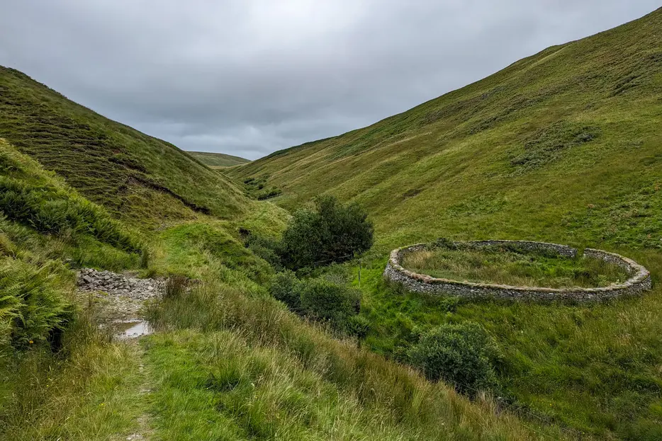
For the low level alternative route stay on the forestry track to continue ahead past the junction where the high level route turns off left. The Way follows the burn, first on the south bank and then across a footbridge to the north side, passing the track to the house at Craigbeck Hope. The track turns NE here and climbs to a col between Gateshaw Rig and Coomb Cairn after which it curves east round the top of the Wamphray Water glen. Recent felling means there are now more views on this section. Where the track makes a U-turn to the south-west the Way leaves it for a path running north beside a burn. This pleasant path leads through dramatic hill terrain with steep sides on either side, eventually reaching the col below Cat Shoulder where the high route rejoins. Note the circular stone sheep pen - these are characteristic of the area and the SUW passes many on the next section.

Stage 4
Cross the col between Croft Head and West Knowe to take the path which climbs past a stone cairn along the edge of a steep craggy ravine in which runs the Selcoth Burn. The narrow path follows the edge of the gorge and then, as the steepness lessens, descends to the burn and crosses it on a footbridge and heads north-east to Ettrick Head, a col with a stile, forestry ahead and a Welcome to the Scottish Borders sign. This little col lies on the watershed of Scotland. All the streams to the west eventually end up in the Atlantic Ocean, those to the east in the North Sea. The Way now enters forest again on a narrow path which reaches a foresty track where you turn right. The track traverses through the trees, and through felled areas above the infant Ettrick Water to eventually descends to Over Phawhope bothy.

Stage 5
The bothy is maintained by volunteers from the Mountain Bothy Association; please help by carrying out any rubbish you find here, and always follow the bothy code when visiting; it is useful for shelter or an overnight stay and has a composting loo. Just past the bothy the track crosses the Ettrick Water and goes down the valley to the house at Potburn. After this keep left at the track junction to climb up to the end of the minor road. This is followed for 8km down the attractive Ettrick Valley through a mix of forest, pasture land with big steep-sided, flat-topped grassy hills rising either side and the occasional house.

Stage 6
The road is finally left at Scabcleuch where a stile over a stone wall on the left, opposite the farm, leads to an old track. This climbs steeply at first, going through a gate and then continuing straight ahead with a fence on your left for a more gentle ascent following the Scabcleuch Burn, aiming eventually for the col at the head of the burn. After a gate and stile keep on the path which bears diagonally left (north east) to traverse the west side of the wide, boggy col.

Stage 7
Pass a signpost and keep ahead (signed Riskinhope) to traverses the eastern slopes of Penistone Knowe above the Whithope Burn. Beyond the little summit of Pikestone Rig the path forks. Ignore the bigger path which heads left downhill but continue ahead, climbing slightly to run along the crest of the hill for a short distance before descending to the ruined farm of Riskinhope Hope. Here the Whithope Burn is crossed on a footbridge (possible wild camp spot) and a path climbs steeply on the far side to a col between Earl's Hill and Fall Law.

Stage 8
Just after the col the Way dips into the edge of a forest and joins a track that leaves the trees and makes a descending traverse to St Mary's Loch with good views of the loch and the hills beyond. The route goes through two gates enclosing newly planted trees, eventually reaching a gate and following a track towards the south end of the loch at Tibbie Shiel's Inn (long closed although a basic campsite remains open here). There is an SUW information shelter. The SUW continues by turning right just before the information board rather than at the sign which points into the locked garden of the former Inn. There is also a cafe just to the west on the A708 road.
Next stage: St Mary's Loch to Traquair

Route Profile