Summary
The Rum Cuillin provide one of the finest but most demanding hill circuits in all Scotland; an unsurpassed combination of mountain and sea with unforgettable views. The route is extremely arduous; whilst the scrambling is mostly straightforward, careful route finding is essential - the route is also very committing with few escape options. It covers the 5 major summits on Rum, including 2 Corbetts and a Fiona.
Grade

Bog Factor

Rating
Distance
Time
(in summer)
Ascent
Terrain
Extremely long and rocky mountain traverse. Scrambling is straightforward if easiest line is found. Return walk is boggy.
Hillwalking in Winter
Please note that hillwalking when there is snow lying requires an ice-axe, crampons and the knowledge, experience and skill to use them correctly. All route descriptions and difficulties given here are for summer conditions. See our Winter Skills page for basic information on the essential skills, techniques and knowledge needed for winter hillwalking.
Getting there
Start
Kinloch Castle.
Public Transport
Ferry to Rum from Mallaig; no transport on the island. Kinloch Castle is 700m from the pier.
Start Grid Ref
NM401995


Stage 1
The route is described from Kinloch Castle - built in sandstone shipped in from Arran and appearing utterly out of place on such a remote island. Rum was once the private domain of the Bullough family who bought the island in 1879 as a private shooting estate. From the front of the castle, head towards the pier and then turn right onto a track along the south side of the castle. Go through a gate on the left to pick up a marked path through the woods beside the burn (Coire Dubh path, marked with red plant symbol). The path passes a small wooden shed and then a hydro building. When it meets a wider path / track, turn left along it. This soon passes a National Nature Reserve marker.

Stage 2
A well constructed path now continues through now sparser, more open woodland, generally keeping close by the Allt Slugan a' Choilich - the burn coming down from Coire Dubh. Height is gained gradually, and the made-up path ends at a small dam on the burn at around 200m. Continue on a rougher path that follows the burn and then swings right to pass between two tall gateposts. The path returns to the burn, keeping high above where it flows through a steep-sided box canyon. Continue until you reach a small old stone dam - now washed out. Use this to cross the burn, then head up grassy ground to pick up the next clear section of path that climbing southeast towards Cnapan Breaca. Once flatter ground is reached head up the open slope to the SSW towards the main ridge; any rocks are easily avoided.

Stage 3
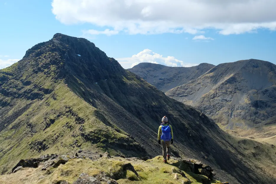
Once on the broad ridge there's a great sudden view of the main peaks of the Rum Cuillin - nearby Hallival, looking steep and rocky, adjacent to the highest mountain on the island, the formidable Askival. More distant is Ainshval, and Trallval to the right. Head towards Hallivall, initially along a broad ridge. There are several rocky bands to negotiate which appear tricky from below, but all are fairly easily avoided by keeping to the left side of the ridge to find gullys or chimneys leading up through them. The ground is covered with tiny burrows - the breeding grounds for Manx Shearwater - amazingly a third of the world's population of these seabirds nest on the Rum Cuillin every summer. You may hear their eerie call from underground; Norse settlers thought it was the noise of trolls, hence the name of Trallval.

Stage 4
On the summit, head S to begin an awkward descent on large slabs and broken scree. A path of loose gravel comes and goes amongst the crags. Descend slowly and carefully to a broad bealach marked with a spot height of 599m. From here continue to climb up to a thin grassy ridge line, used by eagles to feed on unsuspecting shearwater chicks. At the end, you meet the wall of Askival's Pinnacle. There is a clear path to the left (east) avoiding most of the scrambling - the path is occasionally airy but not technical. Move up slowly through boulders, following a faint path to a flattened sandy area, and then the summit cairn. Just before this is a 'jug' move and a sidestep, but this is not technical or exposed.

Stage 5
Askival is the highest of the Rum peaks and an unforgettable viewpoint. The descent is long and steep; head W at first, keeping slightly left of crags. Just above the bealach is another band of crags, which is negotiated via a path slightly to the right. This leads down to the Bealach an Oir (the pass of gold). From here it is possible to descend 50ms or so into Glen Dibidil to replenish water from the streamhead, or alternately bivi for the night, or walk down to Dibidil bothy. On the other side of the bealach, a deer path contours SW but is best ignored. Instead go straight up steeply on grassy slopes until a flattened area is reached. This leads almost directly west until the ascent thins to become more of a ridge line.

Stage 6
Go right (north) past a large 'fan' of rock, and climb carefully through boulders and loose slabs to find a large angled slab, to reach the eastern summit. A short detour along the narrow summit arete leads to the true western summit of Trallval, with superb views to Harris Bay, before returning to the eastern summit. Avoiding somewhat hazardous slabs to the SSW, descend steeply SSE on a vague, winding track, through a small gully and more rockfall to meet a path through loose scree to the Bealach an Fhuarain (Pass of the Springs) under Ainshival. From here, it is possible from here to drop down west towards Loch Fiachanais, or down to Dibidil. To continue the route, go SSW on a path to pass to the right of the crags barring the ridge, then cut back left to steeply climb through alternating scree and grass slopes to attain a flattened spur part way up the ridge.

Stage 7
The ridge above is a narrow rock crest; instead keep to the path that keeps climbing slightly to the left of the ridge, with some very minor scrambling. It trends further from the ridge line before final grass and scree leads up to emerge suddenly by the summit cairn of Ainshval, the second Corbett of the day. Descend south on grass to reach a small bealach, then take the path just to the right of the ridge above the 'nameless coire' before rejoining the crest above the steep section. From point 759m easy grassy ridgewalking leads to the last hill of the day - Sgùrr nan Gillean.

Stage 8
The direct descent to Dibidil bothy is too steep, so instead descend south initially, mostly on grass but with some scree. Below 600m the ground steepends considerably; this section is awkward as there are steep crag which be negotiated through a long gully, or just to its left; great care is needed. Once below this trickier section, the descend is rough but more straightforward on boggy heather, aiming to eventually reach Dibidil bothy, which is an open shelter maintained by volunteers from the Mountain Bothy Association; please help by carrying out any rubbish you find here, and always follow the bothy code when visiting.

Stage 9
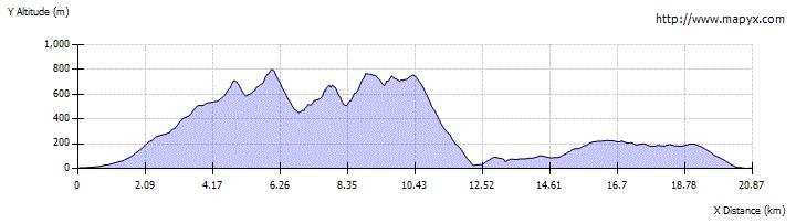
To return to Kinloch, head NE from the bothy door to ford the Dibidil River. This is impassable in spate conditions - lives have been lost here. On the far side pick up the very boggy path back to the village. This climbs initially before mostly contouring the slopes, and has a couple of further burn crossings (though reach smaller than the Dibidil river). It takes 2½ - 3 hours and is 8.5km and is mostly very wet, though a few short sections have been improved. There are excellent views over to Eigg and, on the later stretches, Skye.

Route Profile