walkhighlands

Virtual Highlands goes Hi-Res

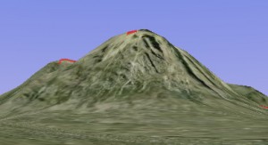
Buachaille Etive Mor as seen in Virtual Highlands

Buachaille Etive Mor as seen in Virtual Highlands

Walkhighlands’ Virtual Highlands is now available in high resolution for most of Scotland. This is possible as Google has updated its satellite imagery of the Scottish Highlands, making programs such as Google Maps, Google Earth et al. show the area in high resolution for the first time.

Virtual Highlands allows you to see an interactive view from any summit; for example, click here for the view from Ben Starav. You can then use the cursor keys to look left and right, and to walk forwards or back. A button allows switching between overhead and first-person view so you can change your location.

Enjoyed this article or find Walkhighlands useful?

Please consider setting up a direct debit donation to support the continued maintenance and updates to Walkhighlands.


Share on 

Share  

You should always carry a backup means of navigation and not rely on a single phone, app or map. Walking can be dangerous and is done entirely at your own risk. Information is provided free of charge; it is every walker's responsibility to check it and to navigate safely.