
 The arrival of autumn provides great opportunities for stunning days out in the Scottish hills, with the gradual change of the mountain flora to its autumn colours.
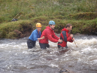
But autumn also heralds its own risk in the hills. The increased rainfall, especially noticeable after the dry summer, can result in some normal burn and river crossings becoming impassable. The Mountaineering Council of Scotland (MCofS) has issued the following warning to walkers and has reduced the price of their DVD on making safe river crossings.
“Even a burn you crossed earlier in the day can have risen to dangerous levels by afternoon, and in remote areas it’s not always possible to know for sure whether a river or burn crossing will be possible until you get there.
“It is much better to plan ahead than be caught out in a remote location, unable to cross back to the safety of your vehicle, tent or bothy.”
Heather Morning, Mountain Safety Advisor with the MCofS recommends: “Anyone heading out into the hills this autumn should take the time to check the weather forecasts.
“If heavy or prolonged rain is forecast it would be advisable to choose a route that crosses glens at the watersheds or as high up the glen as possible, where the burns are much smaller.”
The MCofS currently has an autumn offer on its DVD ‘Water Safety for Walkers’ which gives sound advice on route planning and techniques to ensure a safe burn/river crossing. Now priced at £4.99 (usually £6.99) buy online or call 01738 493943 to order a
Walkhighlands has a range of mountain safety and skills information, and also advises checking weather forecasts and SEPA river levels (for a general indication only) before setting out as well as having back up plans if you need to change route or turn back. Paul Webster from Walkhighlands says, “This is particularly true of long distance routes where people can feel very committed to the planned day’s walking, but routes like the Cape Wrath Trail and the new Scottish National Trail involve a number of river crossings that can be impassable in spate conditions, walkers need to plan for this by using all the information available and having a flexible approach on the day.”