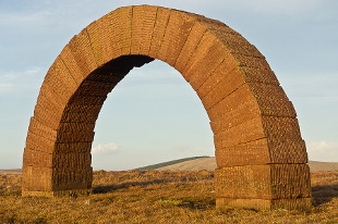
One of the Striding Arches (Photo: Chris Townsend)
The Southern Upland Way is Scotland’s first and only official coast-to-coast long distance route, running across the country from the Atlantic Ocean to the North Sea. From Portpatrick on the west coast the route runs 341 kilometres to Cove and Cockburnspath on the east coast.
The Southern Uplands make up the southernmost part of Scotland, just north of the border with England, and runs from south-west to north-east. The hills are mostly made of a type of sandstone called greywacke that forms gentle, rolling moorlands. However intrusions of granite in the Galloway Hills in the western Southern Uplands and metamorphic rocks in the Tweedsmuir Hills in the heart of the area make for steeper, higher and more rugged terrain.
The Southern Upland Way starts in the west by heading north along the edge of rugged cliffs before turning east to cross sheep pastures, low moorland and forests to the first big hills, rising above Glen Trool. However the route stays low through the Galloway Hills, following paths and tracks through the Galloway Forest Park, before crossing moorland and running through forests to the little towns of St John’s Town of Dalry and Sanquhar. Higher, rougher hills are then traversed to St Mary’s Loch beyond which classic Borders country of heather-clad hills and big rivers is crossed to a final cliff-top walk that mirrors the start. Along the Way there are many historical artefacts from prehistoric standing stones to Victorian mansions as well as modern art works (including kists holding waymerk coins – the whereabouts of these is indicated by the word ultreia on signposts) and rich natural history. This is a living landscape, reflecting the past and changing with the present.
Since he last walked the route in 2003, Chris Townsend noted a number of changes along the route. Most dramatic was the amount of forestry felling and replanting which has taken place now or recently. In some areas, native species are being re-planted, whilst in others more forestry will be grown, and in others large areas of felled plantation is waiting for nature to soften the barren look of newly felled stumps. A number of art works have also been installed along the trail including some of Andy Goldsworthy’s Striding Arches as well as smaller pieces. Chris also noted the proliferation of wind farms which were visible, and in some cases audible, on a number of the days during the walk. Services along the route have improved with some accommodation happy to provide a pick up service from part way along some of the longer sections and baggage transfer is also available. A noteable absence of accommodation at Cockburnspath has now been filled by a new bed and breakfast providing a more comfortable end to the route than the previous enforced wait for transport at the end of the final day.
You can read the route description, complete with photos and OS 1:25,000 mapping here on Walkhighlands.
