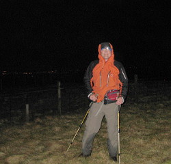
Fraser in the dark on Blairdenon Hill
“We started just after midnight from Loch Chiarian bothy on Saturday morning and climbed Beinn na Cloiche (my Last Graham) in fantastic conditions,” said Fraser. “The sky stayed bright in the north and was pretty much windless. After dawn we crossed Leum Uilleim (Last Corbett) in time to meet friends at Corrour station for the final Munro, Beinn na Lap. Conditions on the summit were pretty poor but everyone enjoyed a good drink and my 7 month old son even was carried up to make a brief visit before being whisked away to Corrour cafe. After the train journey out we picked up the motorhome at Bridge of Orchy and headed to the Ochils for the final Donald and hill of the day Blairdenon Hill. It was 9.30pm before we reached there plus the added bonus of having the wrong map made things critical to locate the hill before dark. We ended up in the wrong area at 11pm and after a panic driven search of my memory of this hill headed for the dark outline of the one I gambled on. It proved to be the correct hill and the insane rush across the moor was not really needed as we had about 30 minutes left before midnight.”
Phew.
NB. Munros are Scottish mountains over 3000 feet. The Corbetts are Scottish mountains over 2500 feet, with 500 feet on descent on all sides. The Grahams are defined as for the Corbetts, but between 2000 and 2500 feet. The Donalds are 2000 summits in the Scottish Lowlands with a definition based on both surrounding descent and distance from a higher summit.
