Summary
North Ronaldsay is the most northerly - and remote - of the Orkney islands. It is almost completely enclosed by a stone wall that keeps the ancient Ronaldsay sheep on the rocky shore; for the most part this unique walk heads round the shore outside the wall. The going can be tiresome in places, but there are fine sandy stretches too, and the island has a flavour all its own.
Grade

Bog Factor

Rating
Distance
Time
(in summer)
Ascent
Terrain
Mostly shoreline walking; some sandy and grassy stretches but also awkward, slow going on tidal rocks and boulders at times.
Are you REALLY ready for winter hills?
Hillwalking when there is snow lying requires an ice-axe, crampons and knowledge of how to use them safely. The description here is for summer conditions.
See our Winter Skills page for basic information on the essential skills, techniques and knowledge needed for winter.
Getting there
Start
North Ronaldsay airport.
Public Transport
There is a ferry service to a pier at the southern end of the island, but it is much more convenient to reach North Ronaldsay using the scheduled air service from Kirkwall. There is a discount on the fare if you wish to stay overnight on the island.
Start Grid Ref
HY748528

Stage 1
As most reach North Ronaldsay by air - a memorable experience on a low-flying plane seating just 8 passengers - the walk is described starting from the airport at Treb. Follow the road from the airport to reach a junction by the war memorial, then turn left to begin the roadwalk to the north end of the island. An old church seen to the left houses an exhibition on the island's history. Continue ahead at a cross-roads; when the road eventually forks, keep left.

Stage 2
Follow the road when it bends right, then left, passing a memorial to two volunteers tragically killed nearby. The track swings left as it reaches the shore just short of the abandoned house at Westness. Go through the gate onto the shore, then turn right to begin the walk outside the wall along the rocky shoreline.

Stage 3
The going is slow and awkward on the stones at times; look out for the North Ronaldsay sheep that graze the kelp on the shore - they have been kept this way for centuries. After ignoring a stile over the dyke there is a particularly awkward section before the going becomes grassy for a time, with views of the great lighthouse ahead.

Stage 4
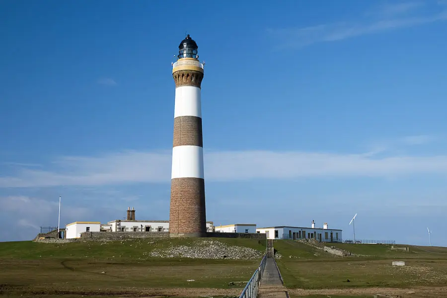
Continue on the stones to the left of Trolla Vatn lochan to round the most northerly point of the island. Follow the shore as far as the foghorn; from here you can detour inland to visit the lighthouse - Britain's tallest built on land. There is a cafe here in season and a small visitor centre; tours are available up the lighthouse tower if pre-booked. Afterwards, return to the shore and continue along it.

Stage 5
The route leads past a series of small circular stone-built enclosures - these were called crues, and were used to grow cabbage plants safe from wind and sheep. Keep between the walls and Dennis Loch to reach the Old Beacon - the original lighthouse and the oldest still standing in the UK. The light featured on TV's Restoration programme, but plans to restore it stalled and it is currently surrounded by scaffold. Keep outside the walls to round the headland below it on the stones.

Stage 6
Continue past the south side of Dennis Loch to reach an old store and pier. From here another very stony stretch of shore continues west, passing below two houses (alternatively you could cut inland for a respite and use the roads). There is a section of rocky shore at Snash Ness (note the path worn into the rock by the sheep) before better going is reached, across the fine sands or the greensward behind Linklet Bay. Continue below the seawall at Hooking to reach a further section of beach, before the stones return to round the Bride's Ness peninsula.

Stage 7
Pass a road end and a prominent cairn as you keep south of a loch, still on the stones. The shore now leads to the remains of a broch at the Point of Burrian, with views to Sanday and grey seals often seen on the rocks. Keep along the shore - with somewhat easier going - to reach South Bay.

Stage 8
Cross the bay, heading up through a gate to gain a road near the far end. Turn left here to head along to the ferry pier (a track off to the right leads to the Bird Observatory which has a lunchtime cafe). At the pier go through a gate and continue walking outside the wall, now above low cliffs. The route leads past a damaged bird hide looking over Loch Gretchen. Continue on stones, rounding two geos and passing the airfield seen to the right. Head over a stile to reach a section with no wall; after a second stile bear diagonally right across the grass to reach a gate and the end of a road leading inland. Head along this to reach a crossroads; turn right here and right again at the war memorial to return to the airport.

Route Profile