Summary
This fabulous walk follows the clifftops, stacks and bays of the coastline between An Gearrannan and Bragar. Although linear, the walk is served by buses. It can be shortened by heading inland to reach the main road at a number of points.
Please read the WARNING below before setting out on this route.


Terrain
Mostly waymarked but some navigation required. Much of the route is pathless; some rough going and boggy ground.
Getting there
Start
Na Gearrrannan (Garenin) Blackhouse village car park.
Public Transport
Bus to An Gearrannan blackhouse village at start; bus from Bragar at end.
Start Grid Ref
NB194441

WARNING
The bridge over Loch Ordais (stage 8) is officially closed as unsafe; take great care.
The information shown above is the latest we have. If you have an update then please email us.
Stage 1
From the car park at the road end begin the walk by heading down the lane through An Gearrannan blackhouse village. After the last house on the right take the path on the right which heads up through a gate, passing the ruins of an old house, following a line of old fence posts. This whole route is marked by wooden marker posts, though the gaps between them can be quite long. Cross a stile and climb towards the highest point on the headland which is marked by a small cairn. There is a spectacular view, especially of the coast to the south.

Stage 2
The vague path now turns east to follow the coast, keeping inland from the steep cliffs with the next marker post usually visible ahead though it requires a little scanning to spot it. As you drop down between Aird Mhòr and Aird Mheadhonach the old ridges of the lazy beds where crofters once grew crops are clearly visible. Cross the burn near a round stone sheep enclosure and follow the posts uphill. The route keeps back from the cliffs, crossing mostly grassy ground with some boggy sections.

Stage 3
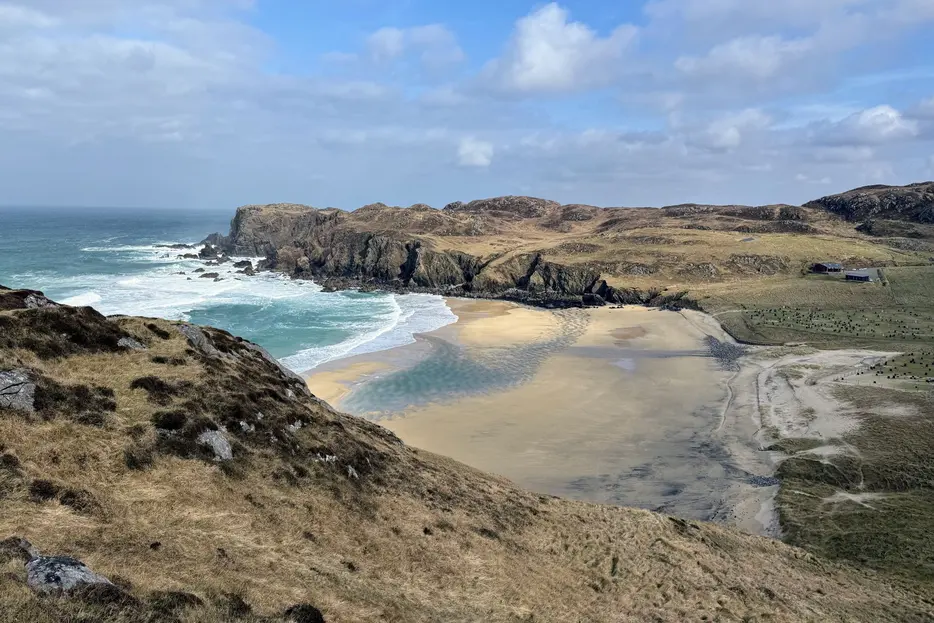
After passing a dramatic narrow headland jutting out into the sea the path climbs up a grassy flank between rocky outcrops, heading slightly inland. Follow the sparse marker posts to cross an area of peat bog aiming directly for the rocky knoll ahead. From here Rubha an Trilleachain with its small natural arch can be seen to the left (north east). The route now descends boggy ground to cross a fence at a stile near the cliffs. Cross the flat boggy area, aiming diagonally slightly right to pick up a clearer path on the far side which crosses another stile. Soon the beach and cemetery at Dail Mòr come into view. The path descends gradually, traversing the steep grassy slopes to reach the inland side of the cemetery. Bear right to cross a bridge and go through the kissing gate onto the road, there are toilets and a parking area here.

Stage 4
Walk up the road for a short distance and at a sharp bend take the path straight ahead between two fences. The path continues on the right side of the fence, with some boggy ground as it climbs. Follow the marker posts up and over the high ground before descending towards another fence - the route of the path can be seen ahead as it follows the right side of the fence. There is a view to Loch Dailbheag to the left before the path reaches the fence and climbs, revealing more views of the loch and beach beyond. It then follows the fence inland, on rough terrain. With a house on the road opposite visible, turn left to cross a stile and follow the path down to a bridge and then up to the road. Turn left to follow the road to the parking area behind the beach.

Stage 5
From the parking area head up the footpath on the right. Ignore the more obvious path that keeps close to the coastline and instead follow the marker posts that lead more directly uphill. Cross a stile - there are great views looking back over Dail Beag with its loch, beach and sea stacks all prominent. Soon the route crosses a stile over a second fence, passes to the right of a rocky outctop, and further on crosses another stile with a drystone wall just beyond.

Stage 6
After a descent the coast eventually draws near once more, with a mighty sea stack at one point. The route keeps well to the north of Loch na Muilne. Go through a pedestrian gate and pass to the right of a very impressive blow hole, with the waves lapping beneath at high tide. The route turns left alongside the fence, then passes to the right of a prominent upright rock as you aim for another stile. The route continues across boggy ground, keeping well left of the fences of croftland.

Stage 7
Cross another stile and continue ahead to eventually reach the shore of the next major bay, Loch Shiabost at yet another stile. Turn right to follow a path running beside the shores of the bay, soon reaching a parking area. From here aim left across the causeway that separates Loch a'Bhaile from the sea - with a beach on your left at low tide. Cross the causeway to meet a minor road and follow this to a T-junction. Turn left here (the route is now marked with white-topped posts) and continue to the end of the road, passing through the gate and then aiming half right through the boggy field, meeting the coastline at the back of a small bay. This section of the coast is more level and the route passes an attractive sandy cove at one point.

Stage 8
The route climbs slightly to cross the remains of a stone wall and at a fence cross a stile a short way inland (don't keep on the outside as the cliff is eroded here) and head for the marker post ahead before descending to go through a gate beyond Fibhig to cross the pebble bank behind the bay. Keep an eye out for markers and climb at first to cross more stiles and descend towards a rockier, flatter area - cross another stile and the route stays a little way back from the sea, soon passing a memorial to 4 people who drowned in 1869 on your left. The route now cuts across the final headland and then keeps close to the rocky low cliffs eventually crossing a final stile and bearing right to follow the coast as it cuts southwards around Port Mhor Bhraga. A grassy path is followed until a wooden footbridge - turn left across this (take care as bridge in poor repair). A grassy track now leads between the sandy bay of Port Mhor Bhraga and Loch Ordais. Eventually a road is met; turn inland (right) at the picnic/parking area to follow the road to Bragar, keeping straight on at a crossroads in the village to meet the main A858 and the bus route beyond.

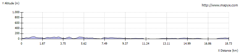
Route Profile