
Apologies to those who have read the following story before but it does illustrate how times and attitudes have changed in Scotland.
Back in the late seventies I was invited to attend a press conference in Glasgow to launch a guidebook to the West Highland Way. The route hadn’t been officially opened but the publishers Constable had produced a guidebook, written by a chap called Tom Hunter.
The publishers also brought John Hillaby with them. Hillaby was a science writer-cum-long-distance-walker who had written Journey Through Britain, an excellent account of walking between Land’s End and John O’Groats, even though it was a little sparse on the Scottish part of the walk…
Hillaby, in his own rather pompous and emphatic way, proceeded to lecture the assembled guests on the benefits of official long distance walking routes, and was extremely critical because Scotland, at the time, didn’t have any.
When it was time for questions, Sandy Cousins, a bulldog of the Scottish conservation movement and a strict upholder of Scottish outdoor traditions, stood up and castigated the publishers and Hillaby in particular for having the temerity to come north and preach to the Scots in their own back garden. “We have no need for southern ideas like ‘official’ long distance walking routes in Scotland, and your West Highland Way is not welcome here,” he roared.
Most of the assembled guests tended to agree with Sandy. Scotland’s traditions of de-facto access were well nurtured and protected and few saw any need to channel folk onto a linear route with signposts to guide them.
However, one guest disagreed. He later said to me, “Sandy means well, but he’s wrong. Routes like the West Highland Way are going to become very popular in Scotland.”
That guest was WH Murray, and in a highly prophetic way he was absolutely correct. The West Highland Way has become a showpiece of the Scottish outdoors and attracts about 85,000 walkers every year, of whom about 30,000 complete the full 96-mile route (according to Wikepedia).
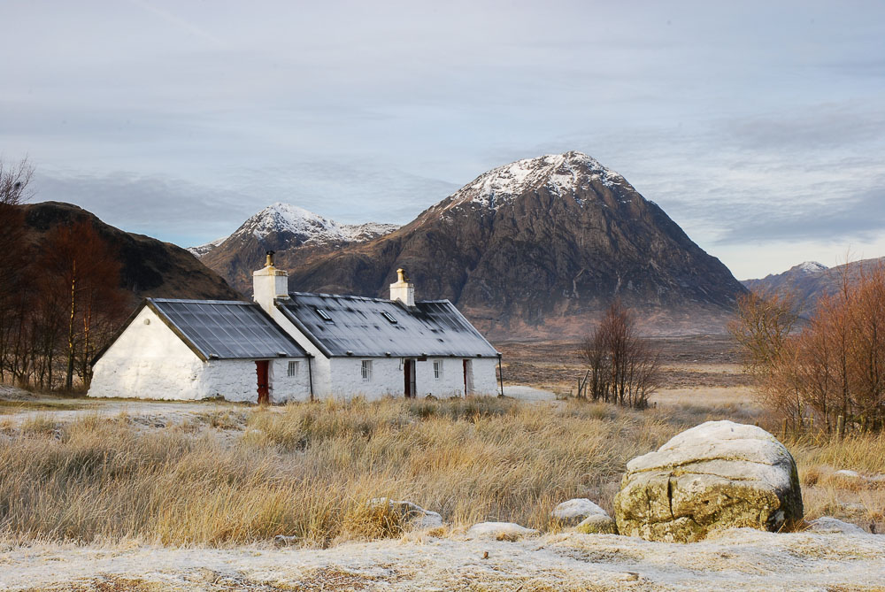
Buachaille Etive Mor from the West Highland Way
However, it did take some time for long distance walking routes to catch on in Scotland. The Countryside Commission for Scotland, then Scottish Natural Heritage, produced three more ‘official’ routes in the years after the opening of the West Highland Way – the Southern Upland Way, the Great Glen Way and the Speyside Way, but those routes have never reached the same level of popularity as the WHW.
It’s not until fairly recently that Scotland has enjoyed a glut of new walking routes, and I believe that’s largely down to the access provisions of the Land Reform (Scotland) Act of 2003. Since then local councils have created many ‘core path networks’ while many independent writers and walkers have created their own routes and published guide-books to them. Routes like St Cuthbert’s Way, the Rob Roy Way, the Cateran Trail, the Ayrshire Coastal Path, the Fife Coastal Path, the Moray Coastal Path and many others have all appeared and are now collectively known as Scotland’s Great Trails.
These routes are nationally promoted trails for “people-powered” journeys. Each is distinctively waymarked, largely off-road and has a range of visitor services. With each trail being at least 25 miles in length, all are suitable for multi-day journeys. Collectively, the 26 different routes provide over 1700 miles of managed paths from the Borders to the Highlands.
In addition there are a number of other published routes that for various reasons don’t qualify for ‘Great Trails’ status. The superb Skye Trail is one and I hope you’ll forgive me for mentioning the Sutherland Trail, a fantastic route between Lochinver and Tongue that I initially put together for a television programme about seven years ago.

On the Skye Trail
What excites me most about this sudden proliferation of new routes is the opportunity to link many of them together into longer walks, reaching into most parts of the country. Such a network of walking routes offers untold possibilities and this was partly the raison d’etre behind my own Scottish National Trail which was launched a couple of years ago. While I use the possessive “my” adjective I should point out that I don’t claim any proprietorial rights to the route.
I simply saw the opportunity of linking up a number of existing trails into one long route that traverses the whole of Scotland from the Borders to Cape Wrath, the most north-western point on the Scottish mainland – if you’ve ever visited John O’Groats you’ll understand why I chose to finish at Cape Wrath!
Earlier this month I had the pleasure of opening a footbridge near St Fillans in Perthshire that completes a lovely walking route between Lochearnhead and Comrie. It follows the route of an old railway along the north shores of Loch Earn and will eventually become part of the proposed Three Saints Way and the Pilgrims’ Trail, a new route that’s being developed between Iona and St. Andrews, and not to be confused with the televised route I walked last year between Iona and Portmahomack in Easter Ross.
This year I’m walking another route for television – this time between the Mull of Galloway and Oban and once again I’ll be linking up many existing trails – the Mull of Galloway Trail, the Ayrshire Coastal Path, the Kintyre Way and the Cowal Way. These long routes that can easily be linked together are marvellous and I suspect poor old Sandy Cousins might be turning in his grave at the thought of it…
So, with signposted and managed long distance walking routes now firmly accepted and enjoyed by so many in Scotland I wonder when that other bugbear of the Scottish outdoors will be considered and addressed. The old issue of signposting the Munros.
Ah, I can sense the antagonism already and I wonder if the old Scottish outdoor establishment is really dead and buried? The signposting of Scotland’s 282 Munros has been a call made by many mainstream commentators including Lesley Riddoch and Ian MacWhirter, both keen walkers but I suspect there may still be more opposition to that than to creating more long distance trails.
On the one side there has always been a tradition of self-dependency on the Scottish hills, the clear belief that hill-goers should be fully versed in the skills of self-preservation, mountain navigation and weather lore. On the other hand, most of us are aware that is not always the case, and the lure of the Munros has attracted all types of folk, including those who are both inexperienced and ill-prepared.
In most other countries in Europe the popular mountain routes are signposted, often with red paint-marks on rocks, so why not in Scotland?
I confess I’ve always been in the anti-waymarking camp myself. I still abhor lines of waymarking cairns, but that dislike stems from environmental reasons more than anything else. The removal of boulders to build waymarking cairns can do a lot of damage to the ground and if we are to have any form of waymarking then I’d much prefer to see the Swiss model of paint-marks on rocks, or even the occasional signpost.
Signs in Glen Mark at start of route to Mount Keen
Thirty-five years ago I’d never have believed we’d see such a proliferation of long distance trails in Scotland. I wonder, in another thirty-five years, if each of our Munros, and maybe the Corbetts too, will have prominent signs proudly proclaiming the route to the summit? What do you think? Or more important, what would you like to see happen? It would be good to hear your thoughts.