Summary
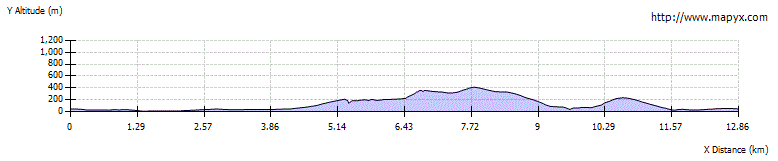
This magnificent walk takes in the main summits of the extremely remote island of Foula. From the airport it follows the coastline to the ferry pier before continuing to the northern part of the island before ascending to Soberlie. The spectacular western coastal cliffs - the highest in the UK outwith St Kilda - are then followed with an extremely steep climb to the top of Da Kame. From there a hill ridge links to Da Sneug - the highest summit on Foula - before dropping down and then climbing to Da Noup - the dramatic southern summit. From here the route returns to the airport; it can be shortened from Da Sneug if time or energy is running out.


Terrain
Boggy initially, then mostly grassy and rough moorland terrain. There is some extremely steep ground on the ascents, particularly up to Da Kame, that require care and some may find disconcerting.
Are you REALLY ready for winter hills?
Hillwalking when there is snow lying requires an ice-axe, crampons and knowledge of how to use them safely. The description here is for summer conditions.
See our Winter Skills page for basic information on the essential skills, techniques and knowledge needed for winter.
Getting there
Start
Foula airstrip.
Public Transport
Foula is served by both air and ferry links from mainland Shetland. Only the air service allows a day visit if not planning to stay on the island overnight, with varying amounts of time between flights on different days. Advance booking is needed as the flights are often full.
Start Grid Ref
HT970376

Stage 1
The walk begins from Foula airstrip, where there is a small waiting room and toilets. You could save a small amount of time by starting north along the road, but our route heads for the coast initially. Wait for any planes to depart and then begin by heading round the northern end of the runway, continuing across very boggy pathless ground (the wettest part of the whole walk) to reach the coastal cliffs to the east. Follow the clifftops northwards, soon passing through a signed gate and continuing to reach a memorial to the first World War - Foula had a population of 100 at this time, and lost 6 of its young men. Continue along the cliffs, rounding the bay of Ham Little - look out for puffins and their burrows at the clifftops. There are a couple of wooden boardwalks and another pedestrian gate as you pass round the far side.

Stage 2
After rounding Da Head o da Baa, Foula's main jetty comes into view across Da Voe; the tiny ferry boat is usually kept safely hauled up above the water. Follow a marker post inland towards a house on the south side of Da Voe, and after passing through a gate turn immediately right on a footpath that leads down to cross a footbridge over the burn that flows into Da Voe. Climb the broad path on the far side to reach a road; the jetty is a short distance to the right here, but our route turns left. After a cattle grid a t-junction with the main Foula road is reached; turn right along this, following it past the island's fine modern school building. The road continues across peaty moorland towards the northern part of the island; there are good views over to Da Sneug on the left, with the bulge of Da Kame to its right.

Stage 3
Eventually the road climbs towards Da Heights, and a junction is reached by a bungalow. The main road bends right here, but our route keeps straight ahead on a smaller road that climbs and then ends by the island waterworks. Keep straight ahead up the broad ridge of stones of grass, climbing towards Soberlie. There are stunning views over the northern end of Foula, with the spectacular Gaada Stack - which has two separate arches - well seen far below.

Stage 4
The great clifftop above Foula's west coast are reached suddenly, but the grassy slopes mean that it is hard to get a view to appreciate their scale at first. Turn left along the grassy clifftops until the slight projection of Summons Head gives a better view of the cliffs, stretching away to Da Kame - the second highest seacliff in the UK, exceeded only by Conachair on St Kilda. This area is often grazed by Foula's free-ranging Shetland ponies.

Stage 5
Continuing along the clifftops, the slope leading up to the summit of Da Kame looks intimidatingly steep - almost impossible from this angle. The slope is, however, grassy and has many ledges, and it is possible for hillwalkers - with great care - to make the ascent without any real difficulties, keeping slightly left on the uppermost section. Nevertheless, the summit of Da Kame is likely to be reached with some relief. The views back are stunning, but the convex slope means that it is not possible to look peer over the great cliffs of Da Kame from here. Instead head southeast along a broad ridge to the bealach below Da Sneug.

Stage 6
The ascent to Da Sneug from here is straightforward, and ends at a large cairn with a trig point alongside. The view - as you'd expect - encompasses the whole of Foula, with Shetland's Westside and Papa Stour also visible on a clear day. This whole area - and much of the upper slopes of Foula - has a huge population of Great Skuas or Bonxies as they are locally know. During the nesting season these birds defend their nests very aggressively, and at such times it is advisable to have a stick projecting up from your rucksack to help prevent them making contact with your head! Descend the southeast ridge, passing a group of standing stones known as the Brethren.

Stage 7
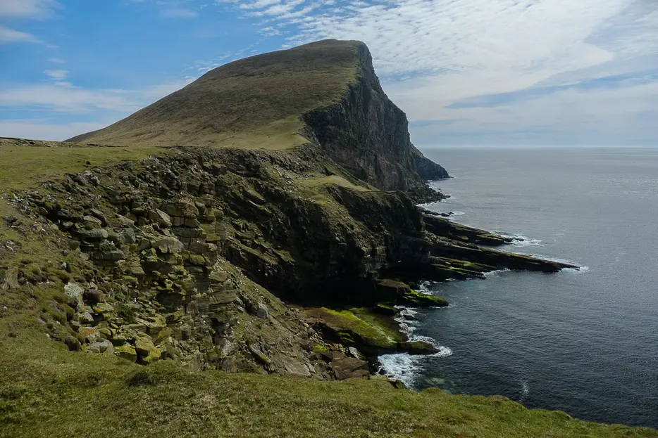
If you've had enough or need to head for your flight, you can shorten the walk by continuing over Hamnafield and descending its SSE ridge to descend directly back towards the airstrip. Otherwise, to continue the complete walk, leave the ridge at the next bealach and then head SSE down rough, pathless slopes into Da Daal. Once down to easier ground in this glen, follow faint paths to the right to reach Foula's great cliffs once more. An amazing feature here is Da Sneck Ida Smaalie - a narrow and very deep rock cleft formed by a landslide; it can be found over to the right as Da Daal meets the coast. It splits the cliffs almost to their base, and is dangerous to enter. From here the coast rises dramatically to the peak of Da Noup to the south.

Stage 8
Head directly up the slope keeping safely away from the edge; it's a steep climb but less steep than Da Kame already tackled; look out for puffins on the way up. Near the top an old drystone dyke is met that leads up to the summit, and a small cairn; again, the views are spectacular, with the lighthouse on South Ness now in view. Descend the grassy slopes to the ESE.

Stage 9
Keep to the right of a fence corner on the way down, and then aim to the right of the coastal drystone wall at the bottom of the slope. It is possible to extend the walk back by continuing right around South Ness on the coast until level with the airstrip, but by this point time is likely to be short. Continue along on the seaward side of the wall until there is a pedestrian gate through it, leading into an open field with the old cemetery and ruined kirk visible across it. Go into this field, then head left from the cemetery towards the farmhouse of Da Biggins. From here a minor road leads back northeast through Da Hametoon. Ignore the first turning on the right and take the second that leads back down to the airstrip. Before taking that final turning it is worth visiting the Baxter Chapel on the left of the road - it is still a working chapel but also has a room containing information and photographs about Foula.

Route Profile